
Topografische Karte Panton
Interaktive Karte
Klicken Sie auf die Karte, um die Höhe anzuzeigen.
Über diese Karte
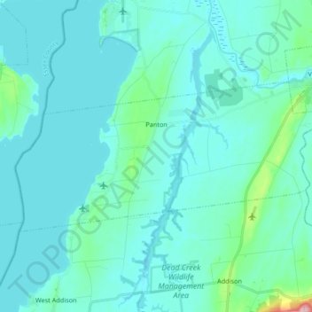
Name: Topografische Karte Panton, Höhe, Relief.
Ort: Panton, Addison County, Vermont, 05491, United States (44.10784 -73.41578 44.16526 -73.24998)
Durchschnittliche Höhe: 42 m
Minimale Höhe: 24 m
Maximale Höhe: 203 m
Andere topografische Karten
Klicken Sie auf eine Karte, um ihre Topografie, ihre Höhe und ihr Relief anzuzeigen.
Monkton
United States > Vermont > Addison County
Monkton, Addison County, Vermont, 05469, United States
Durchschnittliche Höhe: 166 m
Goshen
United States > Vermont > Addison County
Goshen, Addison County, Vermont, United States
Durchschnittliche Höhe: 463 m
Fernville
United States > Vermont > Addison County > Leicester > Fernville
Fernville, Leicester, Addison County, Vermont, 05745, United States
Durchschnittliche Höhe: 242 m
Bridport
United States > Vermont > Addison County > Bridport
Bridport, Addison County, Vermont, 05734, United States
Durchschnittliche Höhe: 65 m
Lake Dunmore
United States > Vermont > Addison County > Salisbury > Lake Dunmore
Lake Dunmore, Salisbury, Addison County, Vermont, 05769, United States
Durchschnittliche Höhe: 192 m
Orwell
United States > Vermont > Addison County
Orwell, Addison County, Vermont, 05760, United States
Durchschnittliche Höhe: 107 m
Starksboro
United States > Vermont > Addison County > Starksboro
Starksboro, Addison County, Vermont, 05487, United States
Durchschnittliche Höhe: 298 m
Winona Lake
United States > Vermont > Addison County > Bristol
Winona Lake, Bristol, Addison County, Vermont, United States
Durchschnittliche Höhe: 188 m
Salisbury
United States > Vermont > Addison County > Salisbury
Salisbury, Addison County, Vermont, 05769, United States
Durchschnittliche Höhe: 237 m
Ripton
United States > Vermont > Addison County
Ripton, Addison County, Vermont, 05766, United States
Durchschnittliche Höhe: 440 m