
Topografische Karte Bengkulu
Interaktive Karte
Klicken Sie auf die Karte, um die Höhe anzuzeigen.
Über diese Karte
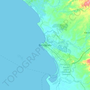
Name: Topografische Karte Bengkulu, Höhe, Relief.
Ort: Bengkulu, Sumatra, Indonesia (-3.95229 102.10238 -3.63229 102.42238)
Durchschnittliche Höhe: 14 m
Minimale Höhe: -3 m
Maximale Höhe: 195 m
The region is at low elevation and can have swamps. In the mid 19th century, malaria and related diseases were common. Bengkulu lies near the Sunda Fault and is prone to earthquakes and tsunamis. The June 2000 Enggano earthquake killed at least 100 people. A recent report predicts that Bengkulu is "at risk of inundation over the next few decades from undersea earthquakes predicted along the coast of Sumatra" A series of earthquakes struck Bengkulu during September 2007, killing 13 people. Bengkulu City has an area of 151.70 km ², and is located on the west coast of Sumatra island, with the province having a coastline about 525 km in length. The area of this city lies parallel to the mountains of Bukit Barisan and face to face with the Indian Ocean.
Andere topografische Karten
Klicken Sie auf eine Karte, um ihre Topografie, ihre Höhe und ihr Relief anzuzeigen.
Universitas Bengkulu
Indonesia > Bengkulu > Muara Bangkahulu > Bengkulu
Universitas Bengkulu, Kandang Limun, Muara Bangkahulu, Bengkulu, Muara Bangkahulu, Bengkulu, Sumatra, 38371, Indonesia
Durchschnittliche Höhe: 5 m
Air Sebayur
Indonesia > Bengkulu > Bengkulu Utara
Air Sebayur, Bengkulu Utara, Bengkulu, Sumatra, Indonesia
Durchschnittliche Höhe: 128 m
Bukit Sari
Indonesia > Bengkulu > Kepahiang
Bukit Sari, Kepahiang, Bengkulu, Sumatra, Indonesia
Durchschnittliche Höhe: 1.122 m
Talang Ulu
Indonesia > Bengkulu > Lebong Utara
Talang Ulu, Lebong Utara, Bengkulu, Indonesia
Durchschnittliche Höhe: 433 m
Kota Baru Santan
Indonesia > Bengkulu > Lebong Utara
Kota Baru Santan, Lebong Utara, Bengkulu, Indonesia
Durchschnittliche Höhe: 566 m
Padang Kala
Indonesia > Bengkulu > Padang Kala
Padang Kala, Bengkulu, Indonesia
Durchschnittliche Höhe: 126 m
Kayu Arang
Indonesia > Bengkulu > Kayu Arang
Kayu Arang, Kampung Melayu, Bengkulu, Indonesia
Durchschnittliche Höhe: 62 m