
Spenden
Rüsten Sie sich für Ihr nächstes Abenteuer:
Als Amazon-Partner erhält diese Website eine Provision für qualifizierte Käufe, ohne zusätzliche Kosten für Sie.
Topografische Karte Sens-Beaujeu
Klicken Sie auf die Karte, um die Höhe anzuzeigen.
Spenden
Rüsten Sie sich für Ihr nächstes Abenteuer:
Als Amazon-Partner erhält diese Website eine Provision für qualifizierte Käufe, ohne zusätzliche Kosten für Sie.
Sens-Beaujeu
Son territoire de plateaux est largement entaillé par la rivière de la Grande Sauldre et son affluent le ruisseau de l’Étang de Couët, formant des vallons humides au paysage encore bocager. La vallée est limitée au sud-ouest par une chaîne de collines couvertes de bois qui, partant de Neuilly en Sancerre (point culminant du canton 392 mètres dans la forêt communale) se dirige vers Aubigny sur Nère. A l'est la colline des Bruyères (365 mètres sur Crézancy) se prolonge sur Sens-Beaujeu (330 mètres) tandis qu'au nord le Bois Briou n'a que 276 mètres d'altitude. Le point le plus bas est à 230 mètres au Parc en limite avec Le Noyer. Les hauteurs de l'Est de la commune sont des collines de silex crétacé occupées par la forêt.
Spenden
Rüsten Sie sich für Ihr nächstes Abenteuer:
Als Amazon-Partner erhält diese Website eine Provision für qualifizierte Käufe, ohne zusätzliche Kosten für Sie.
Über diese Karte
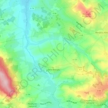
Name: Topografische Karte Sens-Beaujeu, Höhe, Relief.
Durchschnittliche Höhe: 281 m
Minimale Höhe: 215 m
Maximale Höhe: 419 m
Spenden
Rüsten Sie sich für Ihr nächstes Abenteuer:
Als Amazon-Partner erhält diese Website eine Provision für qualifizierte Käufe, ohne zusätzliche Kosten für Sie.
Andere topografische Karten
Klicken Sie auf eine Karte, um ihre Topografie, ihre Höhe und ihr Relief anzuzeigen.
Spenden
Rüsten Sie sich für Ihr nächstes Abenteuer:
Als Amazon-Partner erhält diese Website eine Provision für qualifizierte Käufe, ohne zusätzliche Kosten für Sie.
Spenden
Rüsten Sie sich für Ihr nächstes Abenteuer:
Als Amazon-Partner erhält diese Website eine Provision für qualifizierte Käufe, ohne zusätzliche Kosten für Sie.
Étang de Morue
France > Centre-Val de Loire > Cher > Neuilly-en-Sancerre
Durchschnittliche Höhe: 318 m
Spenden
Rüsten Sie sich für Ihr nächstes Abenteuer:
Als Amazon-Partner erhält diese Website eine Provision für qualifizierte Käufe, ohne zusätzliche Kosten für Sie.
Beaurenard
France > Centre-Val de Loire > Cher > Saint-Hilaire-de-Gondilly
Durchschnittliche Höhe: 204 m
Château de Mehun-sur-Yèvre
France > Centre-Val de Loire > Cher > Mehun-sur-Yèvre > Les Préaux
Durchschnittliche Höhe: 121 m
Spenden
Rüsten Sie sich für Ihr nächstes Abenteuer:
Als Amazon-Partner erhält diese Website eine Provision für qualifizierte Käufe, ohne zusätzliche Kosten für Sie.
Spenden
Rüsten Sie sich für Ihr nächstes Abenteuer:
Als Amazon-Partner erhält diese Website eine Provision für qualifizierte Käufe, ohne zusätzliche Kosten für Sie.
Le Champ Plaide
France > Centre-Val de Loire > Cher > Savigny-en-Sancerre
Durchschnittliche Höhe: 198 m
Spenden
Rüsten Sie sich für Ihr nächstes Abenteuer:
Als Amazon-Partner erhält diese Website eine Provision für qualifizierte Käufe, ohne zusätzliche Kosten für Sie.
Source de l'Indre
France > Centre-Val de Loire > Cher > Saint-Priest-la-Marche > La Ville aux Moines
Durchschnittliche Höhe: 464 m
Le Champ du Noyer
France > Centre-Val de Loire > Cher > Vailly-sur-Sauldre
Durchschnittliche Höhe: 229 m
Spenden
Rüsten Sie sich für Ihr nächstes Abenteuer:
Als Amazon-Partner erhält diese Website eine Provision für qualifizierte Käufe, ohne zusätzliche Kosten für Sie.
Le Gravier
France > Centre-Val de Loire > Cher > La Guerche-sur-l'Aubois
Durchschnittliche Höhe: 196 m
Spenden
Rüsten Sie sich für Ihr nächstes Abenteuer:
Als Amazon-Partner erhält diese Website eine Provision für qualifizierte Käufe, ohne zusätzliche Kosten für Sie.
Spenden
Rüsten Sie sich für Ihr nächstes Abenteuer:
Als Amazon-Partner erhält diese Website eine Provision für qualifizierte Käufe, ohne zusätzliche Kosten für Sie.
Spenden
Rüsten Sie sich für Ihr nächstes Abenteuer:
Als Amazon-Partner erhält diese Website eine Provision für qualifizierte Käufe, ohne zusätzliche Kosten für Sie.
Spenden
Rüsten Sie sich für Ihr nächstes Abenteuer:
Als Amazon-Partner erhält diese Website eine Provision für qualifizierte Käufe, ohne zusätzliche Kosten für Sie.
La Montée de l'Eau
France > Centre-Val de Loire > Cher > Charenton-du-Cher
Durchschnittliche Höhe: 204 m
Spenden
Rüsten Sie sich für Ihr nächstes Abenteuer:
Als Amazon-Partner erhält diese Website eine Provision für qualifizierte Käufe, ohne zusätzliche Kosten für Sie.
La Terre du Noyer
France > Centre-Val de Loire > Cher > Aubigny-sur-Nère > Les Landes
Durchschnittliche Höhe: 191 m
Spenden
Rüsten Sie sich für Ihr nächstes Abenteuer:
Als Amazon-Partner erhält diese Website eine Provision für qualifizierte Käufe, ohne zusätzliche Kosten für Sie.
Spenden
Rüsten Sie sich für Ihr nächstes Abenteuer:
Als Amazon-Partner erhält diese Website eine Provision für qualifizierte Käufe, ohne zusätzliche Kosten für Sie.
Le Parc de Saint-Laurent
France > Centre-Val de Loire > Cher > Vignoux-sur-Barangeon > Le Village aux Rois
Durchschnittliche Höhe: 154 m
Spenden
Rüsten Sie sich für Ihr nächstes Abenteuer:
Als Amazon-Partner erhält diese Website eine Provision für qualifizierte Käufe, ohne zusätzliche Kosten für Sie.
Spenden
Rüsten Sie sich für Ihr nächstes Abenteuer:
Als Amazon-Partner erhält diese Website eine Provision für qualifizierte Käufe, ohne zusätzliche Kosten für Sie.
Les Petits Gimonets
France > Centre-Val de Loire > Cher > Brinon-sur-Sauldre
Durchschnittliche Höhe: 142 m
Spenden
Rüsten Sie sich für Ihr nächstes Abenteuer:
Als Amazon-Partner erhält diese Website eine Provision für qualifizierte Käufe, ohne zusätzliche Kosten für Sie.
Spenden
Rüsten Sie sich für Ihr nächstes Abenteuer:
Als Amazon-Partner erhält diese Website eine Provision für qualifizierte Käufe, ohne zusätzliche Kosten für Sie.
Spenden
Rüsten Sie sich für Ihr nächstes Abenteuer:
Als Amazon-Partner erhält diese Website eine Provision für qualifizierte Käufe, ohne zusätzliche Kosten für Sie.
Les Lavaux
France > Centre-Val de Loire > Cher > Ménétréol-sous-Sancerre
Durchschnittliche Höhe: 202 m
La Guénoistrie
France > Centre-Val de Loire > Cher > Saint-Germain-du-Puy
Durchschnittliche Höhe: 147 m
Spenden
Rüsten Sie sich für Ihr nächstes Abenteuer:
Als Amazon-Partner erhält diese Website eine Provision für qualifizierte Käufe, ohne zusätzliche Kosten für Sie.
Les Fouchards
France > Centre-Val de Loire > Cher > Boulleret > Les Fouchards
Durchschnittliche Höhe: 158 m
Spenden
Rüsten Sie sich für Ihr nächstes Abenteuer:
Als Amazon-Partner erhält diese Website eine Provision für qualifizierte Käufe, ohne zusätzliche Kosten für Sie.
Les Ânes
France > Centre-Val de Loire > Cher > Neuvy-Deux-Clochers > Les Ânes
Durchschnittliche Höhe: 292 m
Spenden
Rüsten Sie sich für Ihr nächstes Abenteuer:
Als Amazon-Partner erhält diese Website eine Provision für qualifizierte Käufe, ohne zusätzliche Kosten für Sie.
Spenden
Rüsten Sie sich für Ihr nächstes Abenteuer:
Als Amazon-Partner erhält diese Website eine Provision für qualifizierte Käufe, ohne zusätzliche Kosten für Sie.
Les Bourdelins
France > Centre-Val de Loire > Cher > Ourouer-les-Bourdelins
Durchschnittliche Höhe: 203 m
Spenden
Rüsten Sie sich für Ihr nächstes Abenteuer:
Als Amazon-Partner erhält diese Website eine Provision für qualifizierte Käufe, ohne zusätzliche Kosten für Sie.
Mornay-Berry
France > Centre-Val de Loire > Cher > Mornay-Berry > Mornay-Berry
Durchschnittliche Höhe: 206 m
Spenden
Rüsten Sie sich für Ihr nächstes Abenteuer:
Als Amazon-Partner erhält diese Website eine Provision für qualifizierte Käufe, ohne zusätzliche Kosten für Sie.