
Topografische Karte Örebro
Interaktive Karte
Klicken Sie auf die Karte, um die Höhe anzuzeigen.
Über diese Karte
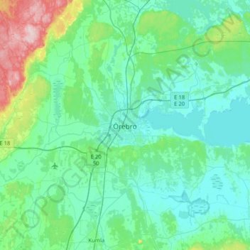
Name: Topografische Karte Örebro, Höhe, Relief.
Ort: Örebro, Örebro kommun, Örebro County, 703 61, Sweden (59.11473 15.05512 59.43473 15.37512)
Durchschnittliche Höhe: 59 m
Minimale Höhe: 19 m
Maximale Höhe: 294 m
Örebro, like the rest of the area close to Mälardalen, has a humid continental climate (Köppen Dfb) that is made milder by the proximity to water and the Gulf Stream which makes it interchangeable with oceanic climates. Summer temperatures occasionally exceed 30 °C (86 °F) albeit not yearly, and temperatures above 5 °C (41 °F) are rare in winter, although frost-free nights sometimes occur. July high temperatures range from 20 °C (68 °F) to 26 °C (79 °F) depending on weather patterns, with a 2002–2014 mean high of around 23.4 °C (74.1 °F). During cold winters, Örebro receives plenty of snowfall. Örebro is far more prone than coastal areas to really harsh frosts with temperatures approaching or below −20 °C (−4 °F) happening almost every winter according to SMHI statistics. The station's setting in a rural location might skew temperatures somewhat compared to the urban area which is also at a slightly lower elevation and nearer Hjälmaren. Especially when considering overnight lows this could render a small urban heat island effect in the city centre.