
Topografische Karte Mansån
Interaktive Karte
Klicken Sie auf die Karte, um die Höhe anzuzeigen.
Über diese Karte
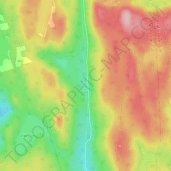
Name: Topografische Karte Mansån, Höhe, Relief.
Ort: Mansån, Sunne kommun, Värmland County, Region Svealand, Sweden (59.88553 13.35250 59.92271 13.35523)
Durchschnittliche Höhe: 271 m
Minimale Höhe: 179 m
Maximale Höhe: 361 m
Andere topografische Karten
Klicken Sie auf eine Karte, um ihre Topografie, ihre Höhe und ihr Relief anzuzeigen.
Hagfors
Sweden > Värmland County > Hagfors
Hagfors, Värmland County, Region Svealand, 683 30, Sweden
Durchschnittliche Höhe: 203 m
Torsby kommun
Torsby kommun, Värmland County, Region Svealand, Sweden
Durchschnittliche Höhe: 354 m
Skoghall
Sweden > Värmland County > Skoghall
Skoghall, Hammarö kommun, Värmland County, Region Svealand, 66334, Sweden
Durchschnittliche Höhe: 48 m
Åkershus
Sweden > Värmland County > Åkershus
Åkershus, Säffle kommun, Värmland County, Region Svealand, Sweden
Durchschnittliche Höhe: 47 m
Årjängs kommun
Årjängs kommun, Värmland County, Region Svealand, Sweden
Durchschnittliche Höhe: 176 m
Dalby distrikt
Sweden > Värmland County > Sysslebäck
Dalby distrikt, Sysslebäck, Torsby, Värmland County, Region Svealand, Sweden
Durchschnittliche Höhe: 315 m
Hagfors
Hagfors, Värmland County, Region Svealand, Sweden
Durchschnittliche Höhe: 256 m
Vänern
Sweden > Värmland County > Åkershus
Vänern, Åkershus, Säffle, Värmland County, Region Svealand, Sweden
Durchschnittliche Höhe: 78 m