
Topografische Karte Municipality of Acharnes
Interaktive Karte
Klicken Sie auf die Karte, um die Höhe anzuzeigen.
Über diese Karte
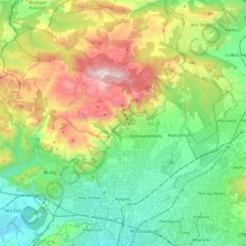
Name: Topografische Karte Municipality of Acharnes, Höhe, Relief.
Durchschnittliche Höhe: 490 m
Minimale Höhe: 103 m
Maximale Höhe: 1.396 m
Andere topografische Karten
Klicken Sie auf eine Karte, um ihre Topografie, ihre Höhe und ihr Relief anzuzeigen.
Chalandri
Greece > Attica > Regional Unit of North Athens
Chalandri, Municipality of Chalandri, Regional Unit of North Athens, Attica, 152 32, Greece
Durchschnittliche Höhe: 222 m
Piraeus
Greece > Attica > Regional Unit of Piraeus
Piraeus, Municipality of Piraeus, Regional Unit of Piraeus, Attica, 185 35, Greece
Durchschnittliche Höhe: 96 m
Olympus
Greece > Attica > Regional Unit of North Athens > Municipal Unit of Psychiko
Olympus, Municipal Unit of Psychiko, Municipality of Filothei - Psychiko, Regional Unit of North Athens, Attica, 154 52, Greece
Durchschnittliche Höhe: 204 m
Vouliagmeni Municipal Unit
Greece > Attica > Regional Unit of East Attica
Vouliagmeni Municipal Unit, Municipality of Vari - Voula - Vouliagmeni, Regional Unit of East Attica, Attica, 166 71, Greece
Durchschnittliche Höhe: 20 m
Athens
Greece > Attica > Regional Unit of Central Athens
Athens, Municipality of Athens, Regional Unit of Central Athens, Attica, 105 57, Greece
Durchschnittliche Höhe: 168 m