
Topografische Karte Los Pedroches
Interaktive Karte
Klicken Sie auf die Karte, um die Höhe anzuzeigen.
Über diese Karte
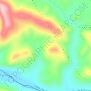
Name: Topografische Karte Los Pedroches, Höhe, Relief.
Durchschnittliche Höhe: 526 m
Minimale Höhe: 432 m
Maximale Höhe: 680 m
Andere topografische Karten
Klicken Sie auf eine Karte, um ihre Topografie, ihre Höhe und ihr Relief anzuzeigen.
Caracollera
España > Castilla-La Mancha > Almodóvar del Campo
Caracollera, Almodóvar del Campo, Ciudad Real, Castilla-La Mancha, España
Durchschnittliche Höhe: 658 m
San Benito
España > Castilla-La Mancha > Almodóvar del Campo
San Benito, Almodóvar del Campo, Valle de Alcudia, Ciudad Real, Castilla-La Mancha, España
Durchschnittliche Höhe: 660 m