
Topografische Karte Yakima County
Interaktive Karte
Klicken Sie auf die Karte, um die Höhe anzuzeigen.
Über diese Karte
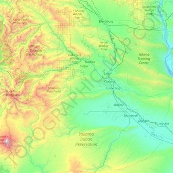
Name: Topografische Karte Yakima County, Höhe, Relief.
Ort: Yakima County, Washington, United States of America (46.04010 -121.52394 47.08911 -119.86542)
Durchschnittliche Höhe: 879 m
Minimale Höhe: 146 m
Maximale Höhe: 3.700 m
Andere topografische Karten
Klicken Sie auf eine Karte, um ihre Topografie, ihre Höhe und ihr Relief anzuzeigen.
Lake Morton-Berrydale
United States of America > Washington > Lake Morton-Berrydale
Lake Morton-Berrydale, King County, Washington, United States of America
Durchschnittliche Höhe: 132 m
Redmond
United States of America > Washington > Redmond
Redmond, King County, Washington, United States of America
Durchschnittliche Höhe: 72 m
Lewis County
United States of America > Washington
Lewis County, Washington, United States of America
Durchschnittliche Höhe: 558 m
Okanogan County
United States of America > Washington > Okanogan County
Okanogan County, Washington, United States of America
Durchschnittliche Höhe: 1.076 m
Clallam County
United States of America > Washington
Clallam County, Washington, United States of America
Durchschnittliche Höhe: 335 m
Island County
United States of America > Washington
Island County, Washington, United States of America
Durchschnittliche Höhe: 98 m