
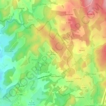
Topografische Karte L'Ebraly de Saint-Dezery
Interaktive Karte
Klicken Sie auf die Karte, um die Höhe anzuzeigen.
Über diese Karte
Name: Topografische Karte L'Ebraly de Saint-Dezery, Höhe, Relief.
Durchschnittliche Höhe: 713 m
Minimale Höhe: 626 m
Maximale Höhe: 811 m
Andere topografische Karten
Klicken Sie auf eine Karte, um ihre Topografie, ihre Höhe und ihr Relief anzuzeigen.
La Tourette
France > Nouvelle-Aquitaine > Corrèze > Ussel
La Tourette, Ussel, Corrèze, Nouvelle-Aquitaine, France métropolitaine, 19200, France
Durchschnittliche Höhe: 677 m
Saint-Dézery
France > Nouvelle-Aquitaine > Corrèze > Ussel
Saint-Dézery, Ussel, Corrèze, Nouvelle-Aquitaine, France métropolitaine, 19200, France
Durchschnittliche Höhe: 706 m
Ponty
France > Nouvelle-Aquitaine > Corrèze > Ussel
Ponty, Ussel, Corrèze, Nouvelle-Aquitaine, France métropolitaine, 19200, France
Durchschnittliche Höhe: 666 m
Saint-Dézery
France > Nouvelle-Aquitaine > Corrèze > Ussel
Saint-Dézery, Ussel, Corrèze, Nouvelle-Aquitaine, France métropolitaine, 19200, France
Durchschnittliche Höhe: 704 m
La Tourette
France > Nouvelle-Aquitaine > Corrèze > Ussel
La Tourette, Ussel, Corrèze, Nouvelle-Aquitaine, France métropolitaine, 19200, France
Durchschnittliche Höhe: 681 m