
Topografische Karte Litcham
Interaktive Karte
Klicken Sie auf die Karte, um die Höhe anzuzeigen.
Über diese Karte
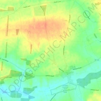
Name: Topografische Karte Litcham, Höhe, Relief.
Ort: Litcham, Breckland District, Norfolk, England, United Kingdom (52.71562 0.74982 52.74859 0.81011)
Durchschnittliche Höhe: 63 m
Minimale Höhe: 42 m
Maximale Höhe: 85 m
Andere topografische Karten
Klicken Sie auf eine Karte, um ihre Topografie, ihre Höhe und ihr Relief anzuzeigen.
Moat
United Kingdom > England > Norfolk > Breckland District > Old Buckenham
Moat, Old Buckenham, Breckland District, Norfolk, England, United Kingdom
Durchschnittliche Höhe: 51 m
Breckland District
United Kingdom > England > Norfolk > Breckland District
Breckland District, Norfolk, East of England, England, United Kingdom
Durchschnittliche Höhe: 37 m
Thetford
United Kingdom > England > Norfolk > Breckland District
Thetford, Breckland District, Norfolk, England, United Kingdom
Durchschnittliche Höhe: 32 m
Mattishall
United Kingdom > England > Norfolk > Breckland District
Mattishall, South Green, Breckland District, Norfolk, England, United Kingdom
Durchschnittliche Höhe: 48 m