
Topografische Karte Rio Rancho
Interaktive Karte
Klicken Sie auf die Karte, um die Höhe anzuzeigen.
Über diese Karte
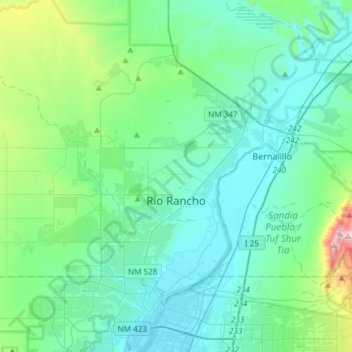
Name: Topografische Karte Rio Rancho, Höhe, Relief.
Ort: Rio Rancho, Sandoval County, New Mexico, United States (35.17992 -106.86521 35.39438 -106.56700)
Durchschnittliche Höhe: 1.672 m
Minimale Höhe: 1.518 m
Maximale Höhe: 2.487 m
Rio Rancho is in an arid climate due to its location in the rain shadow of the Sandia Mountains to the east and the Continental Divide to the west. Rio Rancho receives 8.90 inches of precipitation annually on average. The western portion of the city receives slightly more rain and snowfall due to its higher elevation than that of the more densely developed eastern portion of Rio Rancho.
Andere topografische Karten
Klicken Sie auf eine Karte, um ihre Topografie, ihre Höhe und ihr Relief anzuzeigen.
Bandelier National Monument
United States > New Mexico > Sandoval County
Bandelier National Monument, Sandoval County, New Mexico, United States
Durchschnittliche Höhe: 2.130 m
Santa Ana Pueblo
United States > New Mexico > Sandoval County
Santa Ana Pueblo, Sandoval County, New Mexico, 87004, United States
Durchschnittliche Höhe: 1.558 m
Placitas
United States > New Mexico > Sandoval County
Placitas, Sandoval County, New Mexico, 87043, United States
Durchschnittliche Höhe: 1.864 m
Santo Domingo Pueblo / Kewa
United States > New Mexico > Sandoval County
Santo Domingo Pueblo / Kewa, Sandoval County, New Mexico, United States
Durchschnittliche Höhe: 1.589 m
Cochiti
United States > New Mexico > Sandoval County
Cochiti, Sandoval County, New Mexico, United States
Durchschnittliche Höhe: 1.607 m
Rio Rancho
United States > New Mexico > Sandoval County > Rio Rancho
Rio Rancho, Sandoval County, New Mexico, 87144, United States
Durchschnittliche Höhe: 1.733 m
The Monarch
United States > New Mexico > Sandoval County > Rio Rancho
The Monarch, Rio Rancho, Sandoval County, New Mexico, United States
Durchschnittliche Höhe: 1.731 m
Kasha-Katuwe Tent Rocks National Monument
United States > New Mexico > Sandoval County
Kasha-Katuwe Tent Rocks National Monument, Sandoval County, New Mexico, United States
Durchschnittliche Höhe: 1.852 m
Pajarito Mountain
United States > New Mexico > Sandoval County
Pajarito Mountain, Sandoval County, New Mexico, United States
Durchschnittliche Höhe: 2.936 m
Zia Pueblo
United States > New Mexico > Sandoval County > Zia Pueblo
Zia Pueblo, Sandoval County, New Mexico, United States
Durchschnittliche Höhe: 1.707 m
Corrales
United States > New Mexico > Sandoval County
Corrales, Sandoval County, New Mexico, 87048, United States
Durchschnittliche Höhe: 1.557 m
Valles Caldera
United States > New Mexico > Sandoval County
Valles Caldera, Sandoval County, New Mexico, United States
Durchschnittliche Höhe: 2.772 m
Cochiti Lake
United States > New Mexico > Sandoval County
Cochiti Lake, Sandoval County, New Mexico, 87083, United States
Durchschnittliche Höhe: 1.683 m
Torreon
United States > New Mexico > Sandoval County
Torreon, Eastern Navajo Agency, Sandoval County, New Mexico, United States
Durchschnittliche Höhe: 1.984 m
San Felipe Pueblo
United States > New Mexico > Sandoval County > San Felipe Pueblo
San Felipe Pueblo, Sandoval County, New Mexico, United States
Durchschnittliche Höhe: 1.640 m
Corrales
United States > New Mexico > Sandoval County > Corrales
Corrales, Sandoval County, New Mexico, 87048, United States
Durchschnittliche Höhe: 1.534 m
Jemez Springs
United States > New Mexico > Sandoval County
Jemez Springs, Sandoval County, New Mexico, 87924, United States
Durchschnittliche Höhe: 2.142 m
Cuba
United States > New Mexico > Sandoval County > Cuba
Cuba, Sandoval County, New Mexico, United States
Durchschnittliche Höhe: 2.112 m