
Topografische Karte Wetlina
Interaktive Karte
Klicken Sie auf die Karte, um die Höhe anzuzeigen.
Über diese Karte
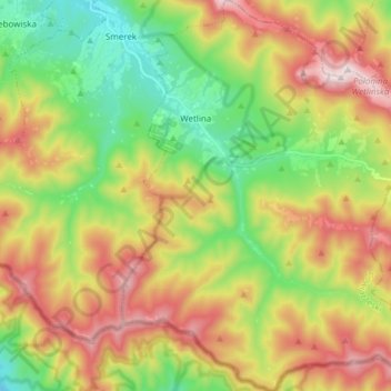
Name: Topografische Karte Wetlina, Höhe, Relief.
Durchschnittliche Höhe: 857 m
Minimale Höhe: 570 m
Maximale Höhe: 1.235 m
The village is located near the source (springs) of the Weltinka river, a primary tributary of the Solinka river. South and west of the village are the Sękowa (1022 m) and Paprotna (1193 m) mountain peaks. East of the village are the range peaks of Połonina Wetlińska, with a maximum elevation of 1253 m.