
Topografische Karte Odell
Interaktive Karte
Klicken Sie auf die Karte, um die Höhe anzuzeigen.
Über diese Karte
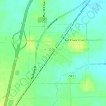
Name: Topografische Karte Odell, Höhe, Relief.
Ort: Odell, Livingston County, Illinois, 60460, United States (40.99484 -88.53361 41.01056 -88.50151)
Durchschnittliche Höhe: 218 m
Minimale Höhe: 211 m
Maximale Höhe: 226 m
Andere topografische Karten
Klicken Sie auf eine Karte, um ihre Topografie, ihre Höhe und ihr Relief anzuzeigen.
Pontiac
United States > Illinois > Livingston County
Pontiac, Pontiac Township, Livingston County, Illinois, 61764, United States
Durchschnittliche Höhe: 199 m
Long Point
United States > Illinois > Livingston County
Long Point, Livingston County, Illinois, United States
Durchschnittliche Höhe: 195 m
Dwight
United States > Illinois > Livingston County
Dwight, Livingston County, Illinois, United States
Durchschnittliche Höhe: 194 m
Cornell
United States > Illinois > Livingston County > Cornell
Cornell, Amity Township, Livingston County, Illinois, 61319, United States
Durchschnittliche Höhe: 192 m
Cornell
United States > Illinois > Livingston County
Cornell, Amity Township, Livingston County, Illinois, United States
Durchschnittliche Höhe: 193 m
Forrest
United States > Illinois > Livingston County
Forrest, Livingston County, Illinois, 61741, United States
Durchschnittliche Höhe: 212 m