
Topografische Karte Canebrake
Interaktive Karte
Klicken Sie auf die Karte, um die Höhe anzuzeigen.
Über diese Karte
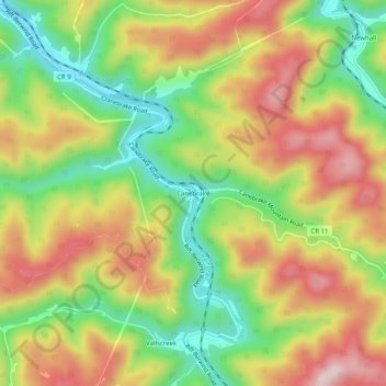
Name: Topografische Karte Canebrake, Höhe, Relief.
Durchschnittliche Höhe: 607 m
Minimale Höhe: 447 m
Maximale Höhe: 774 m
Andere topografische Karten
Klicken Sie auf eine Karte, um ihre Topografie, ihre Höhe und ihr Relief anzuzeigen.
Worth
United States > West Virginia > McDowell County
Worth, McDowell County, West Virginia, 24858, United States
Durchschnittliche Höhe: 731 m
Faraday
United States > West Virginia > McDowell County > Faraday
Faraday, McDowell County, West Virginia, 24601, United States
Durchschnittliche Höhe: 639 m
Yerba
United States > West Virginia > McDowell County
Yerba, McDowell County, West Virginia, 24828, United States
Durchschnittliche Höhe: 563 m
English
United States > West Virginia > McDowell County
English, McDowell County, West Virginia, 24813, United States
Durchschnittliche Höhe: 558 m
Welch
United States > West Virginia > McDowell County
Welch, McDowell County, West Virginia, 24801, United States
Durchschnittliche Höhe: 548 m