
Topografische Karte Town of Wilson
Interaktive Karte
Klicken Sie auf die Karte, um die Höhe anzuzeigen.
Über diese Karte
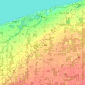
Name: Topografische Karte Town of Wilson, Höhe, Relief.
Durchschnittliche Höhe: 96 m
Minimale Höhe: 70 m
Maximale Höhe: 117 m
Andere topografische Karten
Klicken Sie auf eine Karte, um ihre Topografie, ihre Höhe und ihr Relief anzuzeigen.
Rapids
États-Unis d'Amérique > New York > Niagara County
Rapids, Town of Lockport, Niagara County, New York, États-Unis d'Amérique
Durchschnittliche Höhe: 179 m
Niagara Falls
États-Unis d'Amérique > New York > Niagara County > Niagara Falls
Niagara Falls, Niagara County, New York, 14302, États-Unis d'Amérique
Durchschnittliche Höhe: 158 m
Chutes du Niagara
États-Unis d'Amérique > New York > Niagara County > City of Niagara Falls
Chutes du Niagara, City of Niagara Falls, Niagara County, New York, États-Unis d'Amérique
Durchschnittliche Höhe: 173 m
City of Niagara Falls
États-Unis d'Amérique > New York > Niagara County
City of Niagara Falls, Niagara County, New York, États-Unis d'Amérique
Durchschnittliche Höhe: 180 m