
Spenden
Rüsten Sie sich für Ihr nächstes Abenteuer:
Als Amazon-Partner erhält diese Website eine Provision für qualifizierte Käufe, ohne zusätzliche Kosten für Sie.
Topografische Karte Running Springs
Klicken Sie auf die Karte, um die Höhe anzuzeigen.
Spenden
Rüsten Sie sich für Ihr nächstes Abenteuer:
Als Amazon-Partner erhält diese Website eine Provision für qualifizierte Käufe, ohne zusätzliche Kosten für Sie.
Running Springs
Running Springs is a mountain community in the San Bernardino Mountains. It is an inholding in the San Bernardino National Forest. Situated at the junction of State Route 18 and State Route 330, it is a major gateway to the mountain communities of Lake Arrowhead, Arrowbear, Green Valley Lake, and Big Bear and is the closest community to Snow Valley Mountain Resort. It lies some 16 miles (26 km) northeast of the city of Highland, California, up State Route 330, at an elevation of 6,080 feet (1,850 m). While there is no primary industry in Running Springs, there are service industries geared to the tourism market, as the San Bernardino National Forest is a year-round tourist destination.
Spenden
Rüsten Sie sich für Ihr nächstes Abenteuer:
Als Amazon-Partner erhält diese Website eine Provision für qualifizierte Käufe, ohne zusätzliche Kosten für Sie.
Über diese Karte
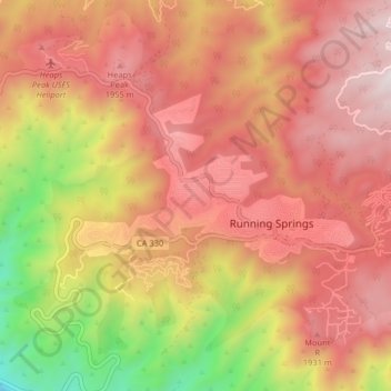
Name: Topografische Karte Running Springs, Höhe, Relief.
Durchschnittliche Höhe: 1.656 m
Minimale Höhe: 875 m
Maximale Höhe: 2.157 m
Spenden
Rüsten Sie sich für Ihr nächstes Abenteuer:
Als Amazon-Partner erhält diese Website eine Provision für qualifizierte Käufe, ohne zusätzliche Kosten für Sie.
Andere topografische Karten
Klicken Sie auf eine Karte, um ihre Topografie, ihre Höhe und ihr Relief anzuzeigen.
Arrowbear Lake
United States > California > San Bernardino County > Running Springs
Arrowbear Lake is an unincorporated community in San Bernardino County, California, United States. Its altitude is 6,086 feet (1,855 m) in the San Bernardino Mountains. It is located east of Running Springs along Highway 18 in the San Bernardino National Forest, a mountain community with a population of 736 in…
Durchschnittliche Höhe: 1.928 m
Running Springs
United States > California > San Bernardino County > Running Springs
Running Springs is a mountain community in the San Bernardino Mountains. It is an inholding in the San Bernardino National Forest. Situated at the junction of State Route 18 and State Route 330, it is a major gateway to the mountain communities of Lake Arrowhead, Arrowbear, Green Valley Lake, and Big Bear and…
Durchschnittliche Höhe: 1.657 m