Geolokalisieren

Topografische Karte Leslie County

Interaktive Karte

Klicken Sie auf die Karte, um die Höhe anzuzeigen.

Über diese Karte

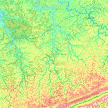
Name: Topografische Karte Leslie County, Höhe, Relief.

Ort: Leslie County, Kentucky, USA (36.88305 -83.55592 37.32058 -83.16487)

Durchschnittliche Höhe: 457 m

Minimale Höhe: 232 m

Maximale Höhe: 1.010 m

Andere topografische Karten

Klicken Sie auf eine Karte, um ihre Topografie, ihre Höhe und ihr Relief anzuzeigen.

Georgetown

USA > Kentucky > Georgetown

Georgetown, Scott County, Kentucky, 40324, USA

Durchschnittliche Höhe: 265 m

Ulysses

USA > Kentucky > Ulysses

Ulysses, Lawrence County, Kentucky, 41264, USA

Durchschnittliche Höhe: 238 m

Hollyhill

USA > Kentucky > Hollyhill

Hollyhill, McCreary County, Kentucky, USA

Durchschnittliche Höhe: 384 m

Grayson County

USA > Kentucky

Grayson County, Kentucky, USA

Durchschnittliche Höhe: 196 m

Nelse

USA > Kentucky > Nelse

Nelse, Pike County, Kentucky, 41562, USA

Durchschnittliche Höhe: 315 m

Hart County

USA > Kentucky

Hart County, Kentucky, USA

Durchschnittliche Höhe: 219 m

Dawkins

USA > Kentucky > Dawkins

Dawkins, Johnson County, Kentucky, 41268, USA

Durchschnittliche Höhe: 238 m

Avoca

USA > Kentucky > Avoca

Avoca, Jefferson County, Kentucky, 40245, USA

Durchschnittliche Höhe: 213 m

Bell County

USA > Kentucky

Bell County, Kentucky, USA

Durchschnittliche Höhe: 498 m

Straw

USA > Kentucky > Straw

Straw, Edmonson County, Kentucky, 42259, USA

Durchschnittliche Höhe: 225 m