
Topografische Karte Chavin Archaeological Site
Interaktive Karte
Klicken Sie auf die Karte, um die Höhe anzuzeigen.
Über diese Karte
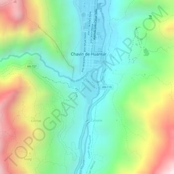
Name: Topografische Karte Chavin Archaeological Site, Höhe, Relief.
Durchschnittliche Höhe: 3.407 m
Minimale Höhe: 3.118 m
Maximale Höhe: 3.902 m
Chavín de Huántar is an archaeological site in Peru, containing ruins and artifacts constructed as early as 1200 BC, and occupied until around 400–500 BC by the Chavín, a major pre-Inca culture. The site is located in the Ancash Region, 434 kilometers (270 mi) north of Lima, at an elevation of 3,180 meters (10,430 ft), east of the Cordillera Blanca at the start of the Conchucos Valley.