
Topografische Karte Opole County
Interaktive Karte
Klicken Sie auf die Karte, um die Höhe anzuzeigen.
Über diese Karte
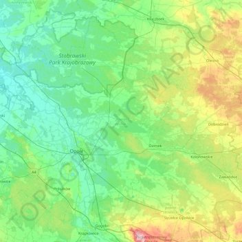
Name: Topografische Karte Opole County, Höhe, Relief.
Ort: Opole County, Opole Voivodeship, Poland (50.50160 17.46624 50.96807 18.35442)
Durchschnittliche Höhe: 192 m
Minimale Höhe: 136 m
Maximale Höhe: 398 m
Andere topografische Karten
Klicken Sie auf eine Karte, um ihre Topografie, ihre Höhe und ihr Relief anzuzeigen.
Olesno
Poland > Opole Voivodeship > Olesno County
Olesno, gmina Olesno, Olesno County, Opole Voivodeship, 46-300, Poland
Durchschnittliche Höhe: 246 m
Narok
Poland > Opole Voivodeship > Opole County > Narok
Narok, gmina Dąbrowa, Opole County, Opole Voivodeship, Poland
Durchschnittliche Höhe: 149 m
Nysa
Poland > Opole Voivodeship > Nysa
Nysa, gmina Nysa, Nysa County, Opole Voivodeship, Poland
Durchschnittliche Höhe: 202 m
Przywory
Poland > Opole Voivodeship > Przywory
Przywory, gmina Tarnów Opolski, Opole County, Opole Voivodeship, Poland
Durchschnittliche Höhe: 160 m
Opole
Poland > Opole Voivodeship > Opole
Opole, Opole Voivodeship, Poland
Durchschnittliche Höhe: 161 m
Niemodlin
Poland > Opole Voivodeship > Niemodlin > Niemodlin
Niemodlin, gmina Niemodlin, Opole County, Opole Voivodeship, 49-100, Poland
Durchschnittliche Höhe: 170 m