
Topografische Karte Flathead Lake
Interaktive Karte
Klicken Sie auf die Karte, um die Höhe anzuzeigen.
Über diese Karte
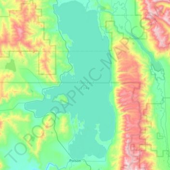
Name: Topografische Karte Flathead Lake, Höhe, Relief.
Ort: Flathead Lake, Lake County, Montana, United States (47.66697 -114.34951 48.08868 -114.01516)
Durchschnittliche Höhe: 1.168 m
Minimale Höhe: 823 m
Maximale Höhe: 2.301 m
Andere topografische Karten
Klicken Sie auf eine Karte, um ihre Topografie, ihre Höhe und ihr Relief anzuzeigen.
Wild Horse Island
United States > Montana > Lake County
Wild Horse Island, Lake County, Montana, United States
Durchschnittliche Höhe: 916 m
Picture Lake
United States > Montana > Lake County
Picture Lake, Lake County, Montana, United States
Durchschnittliche Höhe: 2.220 m
Kicking Horse
United States > Montana > Lake County
Kicking Horse, Lake County, Montana, United States
Durchschnittliche Höhe: 938 m