
Topografische Karte Belwood Lake Boat Launch
Interaktive Karte
Klicken Sie auf die Karte, um die Höhe anzuzeigen.
Über diese Karte
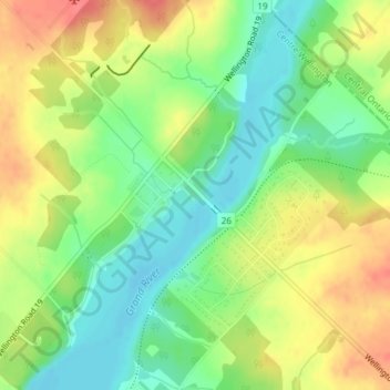
Name: Topografische Karte Belwood Lake Boat Launch, Höhe, Relief.
Durchschnittliche Höhe: 443 m
Minimale Höhe: 415 m
Maximale Höhe: 476 m
Andere topografische Karten
Klicken Sie auf eine Karte, um ihre Topografie, ihre Höhe und ihr Relief anzuzeigen.
Belwood Quarry
Canada > Ontario > Wellington County > Centre Wellington
Belwood Quarry, Centre Wellington, Wellington County, Ontario, Canada
Durchschnittliche Höhe: 424 m
Elora Gorge
Canada > Ontario > Wellington County > Centre Wellington
Elora Gorge, Centre Wellington, Wellington County, Ontario, N0B 1S0, Canada
Durchschnittliche Höhe: 385 m
Fergus
Canada > Ontario > Wellington County > Centre Wellington
Fergus, Centre Wellington, Wellington County, Southwestern Ontario, Ontario, N1M 1P6, Canada
Durchschnittliche Höhe: 415 m
Elora
Canada > Ontario > Wellington County > Centre Wellington
Elora, Centre Wellington, Wellington County, Ontario, N1M 1K4, Canada
Durchschnittliche Höhe: 395 m
Ennotville
Canada > Ontario > Wellington County > Centre Wellington
Ennotville, Centre Wellington, Wellington County, Ontario, Canada
Durchschnittliche Höhe: 391 m