
Topografische Karte Bloomington
Interaktive Karte
Klicken Sie auf die Karte, um die Höhe anzuzeigen.
Über diese Karte
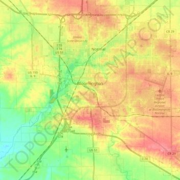
Name: Topografische Karte Bloomington, Höhe, Relief.
Ort: Bloomington, McLean County, Illinois, United States (40.42944 -89.06772 40.51835 -88.86354)
Durchschnittliche Höhe: 246 m
Minimale Höhe: 210 m
Maximale Höhe: 280 m
Bloomington is located at 40°29′03″N 88°59′37″W. The city is at an elevation of 797 feet (243 m) above sea level. According to the 2010 census, Bloomington has a total area of 27.229 square miles (70.52 km2), of which 27.22 square miles (70.50 km2) (or 99.97%) is land and 0.009 square miles (0.02 km2) (or 0.03%) is water.
Andere topografische Karten
Klicken Sie auf eine Karte, um ihre Topografie, ihre Höhe und ihr Relief anzuzeigen.
Hudson
United States > Illinois > McLean County
Hudson, McLean County, Illinois, United States
Durchschnittliche Höhe: 234 m
Towanda
United States > Illinois > McLean County
Towanda, McLean County, Illinois, 61776, United States
Durchschnittliche Höhe: 239 m
Normal
United States > Illinois > McLean County
Normal, McLean County, Illinois, United States
Durchschnittliche Höhe: 249 m
Anchor
United States > Illinois > McLean County
Anchor, McLean County, Illinois, United States
Durchschnittliche Höhe: 235 m