
Topografische Karte Pine Hill
Interaktive Karte
Klicken Sie auf die Karte, um die Höhe anzuzeigen.
Über diese Karte
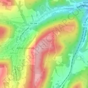
Name: Topografische Karte Pine Hill, Höhe, Relief.
Ort: Pine Hill, Allegany County, New York, 14803, USA (42.25696 -77.77810 42.25706 -77.77800)
Durchschnittliche Höhe: 567 m
Minimale Höhe: 479 m
Maximale Höhe: 671 m
Andere topografische Karten
Klicken Sie auf eine Karte, um ihre Topografie, ihre Höhe und ihr Relief anzuzeigen.
Staten Island
Staten Island, Richmond County, New York, USA
Durchschnittliche Höhe: 11 m
East Maine
USA > New York > East Maine
East Maine, Maine Town, Broome County, New York, USA
Durchschnittliche Höhe: 433 m
Mount Warren
Mount Warren, Town of Bovina, Delaware County, New York, USA
Durchschnittliche Höhe: 677 m
Buchanan
USA > New York > Buchanan > Town of Cortlandt
Buchanan, Town of Cortlandt, Westchester County, New York, 10511, USA
Durchschnittliche Höhe: 27 m
Twin Mountains
Twin Mountains, Franklin County, New York, USA
Durchschnittliche Höhe: 553 m
Livingston Island
Livingston Island, Town of Philipstown, Putnam County, New York, 10922, USA
Durchschnittliche Höhe: 156 m
Crows Nest
Crows Nest, Saint Lawrence County, New York, USA
Durchschnittliche Höhe: 114 m
Falls Creek
Falls Creek, Town of Delhi, Delaware County, New York, 13753, USA
Durchschnittliche Höhe: 515 m
Flat Top Mountain
Flat Top Mountain, Franklin County, New York, USA
Durchschnittliche Höhe: 568 m
Lake Champlain
Lake Champlain, Essex County, New York, USA
Durchschnittliche Höhe: 341 m
Avalanche Lake
Avalanche Lake, Avalanche Pass Trail, Essex County, New York, USA
Durchschnittliche Höhe: 1.066 m
Big Bear Mountain
Big Bear Mountain, Town of Johnsburg, Warren County, New York, USA
Durchschnittliche Höhe: 616 m