
Spenden
Rüsten Sie sich für Ihr nächstes Abenteuer:
Als Amazon-Partner erhält diese Website eine Provision für qualifizierte Käufe, ohne zusätzliche Kosten für Sie.
Topografische Karte Le Pommeret
Klicken Sie auf die Karte, um die Höhe anzuzeigen.
Spenden
Rüsten Sie sich für Ihr nächstes Abenteuer:
Als Amazon-Partner erhält diese Website eine Provision für qualifizierte Käufe, ohne zusätzliche Kosten für Sie.
Über diese Karte
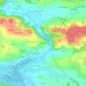
Name: Topografische Karte Le Pommeret, Höhe, Relief.
Durchschnittliche Höhe: 26 m
Minimale Höhe: -2 m
Maximale Höhe: 79 m
Spenden
Rüsten Sie sich für Ihr nächstes Abenteuer:
Als Amazon-Partner erhält diese Website eine Provision für qualifizierte Käufe, ohne zusätzliche Kosten für Sie.
Andere topografische Karten
Klicken Sie auf eine Karte, um ihre Topografie, ihre Höhe und ihr Relief anzuzeigen.
La Gacilly
France > Bretagne > Morbihan > La Gacilly
La superficie de la commune est de 1 648 hectares ; son altitude varie de 4 à 98 mètres.
Durchschnittliche Höhe: 41 m
Glénac
France > Bretagne > Morbihan > La Gacilly
La superficie de l’ancienne commune est de 1 370 hectares (13,7 km2) ; son altitude varie entre 2 et 87 m.
Durchschnittliche Höhe: 31 m
La Chapelle-Gaceline
France > Bretagne > Morbihan > La Gacilly
La superficie de la commune est de 779 hectares ; son altitude varie de 5 à 52 mètres.
Durchschnittliche Höhe: 25 m
La Gacilly
France > Bretagne > Morbihan > La Gacilly
La superficie de la commune est de 1 648 hectares ; son altitude varie de 4 à 98 mètres.
Durchschnittliche Höhe: 41 m
Spenden
Rüsten Sie sich für Ihr nächstes Abenteuer:
Als Amazon-Partner erhält diese Website eine Provision für qualifizierte Käufe, ohne zusätzliche Kosten für Sie.