
Topografische Karte Rosendale
Interaktive Karte
Klicken Sie auf die Karte, um die Höhe anzuzeigen.
Über diese Karte
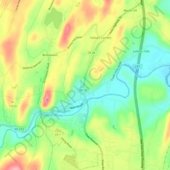
Name: Topografische Karte Rosendale, Höhe, Relief.
Durchschnittliche Höhe: 65 m
Minimale Höhe: 5 m
Maximale Höhe: 136 m
Andere topografische Karten
Klicken Sie auf eine Karte, um ihre Topografie, ihre Höhe und ihr Relief anzuzeigen.
Eagle Mountain
États-Unis d'Amérique > New York > Ulster County
Eagle Mountain, Ulster County, New York, États-Unis d'Amérique
Durchschnittliche Höhe: 893 m
Town of Woodstock
États-Unis d'Amérique > New York > Ulster County
Town of Woodstock, Ulster County, New York, États-Unis d'Amérique
Durchschnittliche Höhe: 332 m
High Falls
États-Unis d'Amérique > New York > Ulster County > Town of Marbletown
High Falls, Town of Marbletown, Ulster County, New York, États-Unis d'Amérique
Durchschnittliche Höhe: 77 m
Woodstock
États-Unis d'Amérique > New York > Ulster County > Woodstock
Woodstock, Town of Woodstock, Ulster County, New York, 12498, États-Unis d'Amérique
Durchschnittliche Höhe: 248 m
Phoenicia
États-Unis d'Amérique > New York > Ulster County > Town of Shandaken
Phoenicia, Town of Shandaken, Ulster County, New York, États-Unis d'Amérique
Durchschnittliche Höhe: 349 m