
Topografische Karte Quarndon
Interaktive Karte
Klicken Sie auf die Karte, um die Höhe anzuzeigen.
Über diese Karte
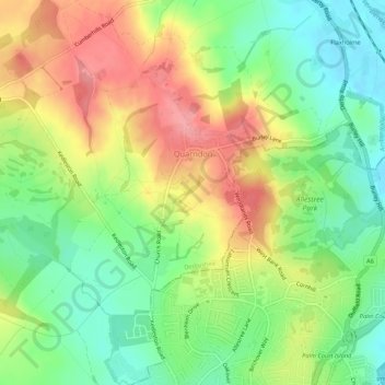
Name: Topografische Karte Quarndon, Höhe, Relief.
Ort: Quarndon, Amber Valley, Derbyshire, England, United Kingdom (52.94631 -1.52417 52.97845 -1.48333)
Durchschnittliche Höhe: 96 m
Minimale Höhe: 51 m
Maximale Höhe: 149 m
52°58′8″N 1°29′36″W / 52.96889°N 1.49333°W / 52.96889; -1.49333 This directional compass, provides details of bearings, distances, elevations and dates of nearly 50 places of special interest and was unveiled on 29 September 2001. It stands on an 8-ton block of Derbyshire gritstone – 140 metres above sea level – funded by the will of the third Viscount Scarsdale who died in 2000 aged 76.
Andere topografische Karten
Klicken Sie auf eine Karte, um ihre Topografie, ihre Höhe und ihr Relief anzuzeigen.
Ironville
United Kingdom > England > Derbyshire > Amber Valley
Ironville, Amber Valley, Derbyshire, England, NG16 5NF, United Kingdom
Durchschnittliche Höhe: 107 m