Geolokalisieren
👉 Easily get elevation data in JSON, GeoTIFF and KML formats using Elevation API
Vielen Dank für die Unterstützung dieser Website ❤️
Spenden

Topografische Karte Mangaluru

Klicken Sie auf die Karte, um die Höhe anzuzeigen.

Mangaluru

Mangalore is also the administrative headquarters of the Dakshina Kannada district; it is a commercial, industrial, educational, healthcare, and startup hub. The city's international airport is the second-largest and second-busiest airport in Karnataka. Mangalore City Corporation is responsible for the civic administration which manages the 60 wards of the city. Its landscape is characterised by rolling hills, coconut palms, rivers, and hard laterite soil. India's first 3D planetarium with 8K resolution display is located in the city. Mangalore is included as one of the cities in the Smart Cities Mission list and is among the 100 smart cities to be developed in India. It has an average elevation of 22 m (72 ft) above mean sea level. It has a tropical monsoon climate and is under the influence of the southwest monsoon. In 2017, Mangalore was ranked the 48th best city in the world to live in by a US survey, and the only Indian city in the top 50. It has its own International Airport which is around 15 km from the city.

Wikipedia (CC-BY-SA 3.0)

👉 Easily get elevation data in JSON, GeoTIFF and KML formats using Elevation API
Vielen Dank für die Unterstützung dieser Website ❤️
Spenden

Über diese Karte

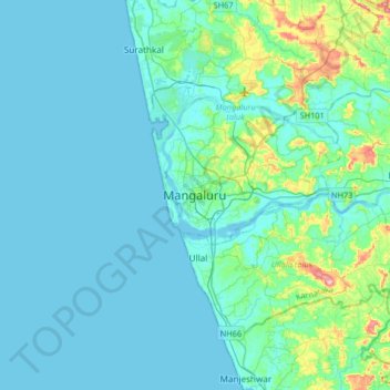
Name: Topografische Karte Mangaluru, Höhe, Relief.

Ort: Mangaluru, Mangaluru taluk, Dakshina Kannada, Karnataka, 575001, India (12.70981 74.68301 13.02981 75.00301)

Durchschnittliche Höhe: 25 m

Minimale Höhe: -2 m

Maximale Höhe: 205 m

Andere topografische Karten

Klicken Sie auf eine Karte, um ihre Topografie, ihre Höhe und ihr Relief anzuzeigen.

Attavara Katte Park

India > Karnataka > Mangaluru taluk > Mangaluru

Durchschnittliche Höhe: 26 m

Tannirbhavi Beach

India > Karnataka > Mangaluru taluk > Tanniru Bavi

Durchschnittliche Höhe: 4 m

Kadri Park

India > Karnataka > Mangaluru taluk > Mangaluru

Durchschnittliche Höhe: 44 m

Jeppu Park

India > Karnataka > Mangaluru taluk > Mangaluru

Durchschnittliche Höhe: 13 m

Vielen Dank für die Unterstützung dieser Website ❤️
Spenden

Rüsten Sie sich für Ihr nächstes Abenteuer:

Als Amazon-Partner erhält diese Website eine Provision für qualifizierte Käufe, ohne zusätzliche Kosten für Sie.

Jeppu Park

India > Karnataka > Mangaluru taluk > Mangaluru

Durchschnittliche Höhe: 13 m

Rüsten Sie sich für Ihr nächstes Abenteuer:

🧭Profi-Marschkompasse - Präzise Spiegelkompasse für die klassische Geländenavigation
🔐Zelt Schloss Sicherheit - Schützt Ausrüstung beim Campen
🥾Wanderschuhe (Damen) - Ergonomische Trekkingschuhe für optimalen Halt
📱Outdoor-Handyhalterungen - Sichere Befestigung für die Navigation am Lenker
🔥Campingkocher Gas - Leistungsstarker Gaskocher für Outdoor‑Küche

Als Amazon-Partner erhält diese Website eine Provision für qualifizierte Käufe, ohne zusätzliche Kosten für Sie.