
Topografische Karte Oxbow Lake
Interaktive Karte
Klicken Sie auf die Karte, um die Höhe anzuzeigen.
Über diese Karte
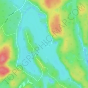
Name: Topografische Karte Oxbow Lake, Höhe, Relief.
Durchschnittliche Höhe: 400 m
Minimale Höhe: 372 m
Maximale Höhe: 455 m
Andere topografische Karten
Klicken Sie auf eine Karte, um ihre Topografie, ihre Höhe und ihr Relief anzuzeigen.
Limberlost Forest and Wildlife Reserve
Canada > Ontario > Muskoka District > Lake of Bays Township
Limberlost Forest and Wildlife Reserve, Lake of Bays Township, District Municipality of Muskoka, Muskoka District, Central Ontario, Ontario, Canada
Durchschnittliche Höhe: 400 m
Tackaberry Lake
Canada > Ontario > Muskoka District > Lake of Bays Township
Tackaberry Lake, Lake of Bays Township, District Municipality of Muskoka, Muskoka District, Central Ontario, Ontario, Canada
Durchschnittliche Höhe: 338 m
Dwight
Canada > Ontario > Muskoka District > Lake of Bays Township
Dwight, Lake of Bays Township, District Municipality of Muskoka, Muskoka District, Central Ontario, Ontario, Canada
Durchschnittliche Höhe: 341 m