
Topografische Karte Knowlton
Interaktive Karte
Klicken Sie auf die Karte, um die Höhe anzuzeigen.
Über diese Karte
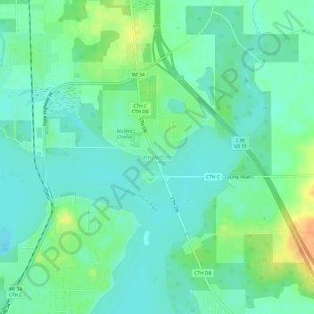
Name: Topografische Karte Knowlton, Höhe, Relief.
Ort: Knowlton, Marathon County, Wisconsin, United States (44.69633 -89.69969 44.73633 -89.65969)
Durchschnittliche Höhe: 346 m
Minimale Höhe: 334 m
Maximale Höhe: 372 m
Andere topografische Karten
Klicken Sie auf eine Karte, um ihre Topografie, ihre Höhe und ihr Relief anzuzeigen.
Wausau
United States > Wisconsin > Marathon County
Wausau, Marathon County, Wisconsin, United States
Durchschnittliche Höhe: 394 m
Village of Weston
United States > Wisconsin > Marathon County
Village of Weston, Marathon County, Wisconsin, 54476, United States
Durchschnittliche Höhe: 371 m
Schofield
United States > Wisconsin > Marathon County
Schofield, Marathon County, Wisconsin, United States
Durchschnittliche Höhe: 364 m
Town of Johnson
United States > Wisconsin > Marathon County
Town of Johnson, Marathon County, Wisconsin, United States
Durchschnittliche Höhe: 433 m
Bypass Channel Wisconsin River
United States > Wisconsin > Marathon County > Wausau
Bypass Channel Wisconsin River, River District, Wausau, Marathon County, Wisconsin, 54403, United States
Durchschnittliche Höhe: 371 m
Athens
United States > Wisconsin > Marathon County > Athens
Athens, Marathon County, Wisconsin, United States
Durchschnittliche Höhe: 420 m
Rib Mountain
United States > Wisconsin > Marathon County > Rib Mountain
Rib Mountain, Town of Stettin, Marathon County, Wisconsin, 54401, United States
Durchschnittliche Höhe: 380 m