
Topografische Karte Keronvel
Klicken Sie auf die Karte, um die Höhe anzuzeigen.
Über diese Karte
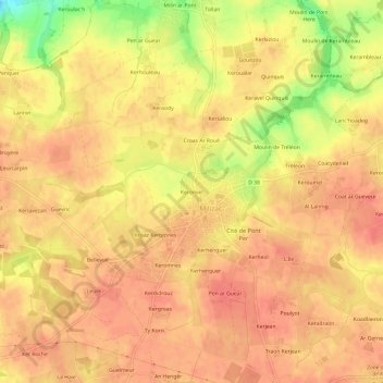
Name: Topografische Karte Keronvel, Höhe, Relief.
Durchschnittliche Höhe: 85 m
Minimale Höhe: 45 m
Maximale Höhe: 99 m
Andere topografische Karten
Klicken Sie auf eine Karte, um ihre Topografie, ihre Höhe und ihr Relief anzuzeigen.
Guipronvel
France > Bretagne > Finistère > Milizac-Guipronvel
Formée d'un morceau du plateau du Léon (une pénéplaine cristalline constituée de granit de Saint-Renan, gneiss et micaschiste), l'ancienne commune de Guipronvel est en pente douce vers le nord (les altitudes les plus élevées se trouvent dans le sud du finage communal : 89 mètres entre Gouézou et Le…
Durchschnittliche Höhe: 65 m
Milizac
France > Bretagne > Finistère > Milizac-Guipronvel
Milizac se trouve sur le plateau du Léon qui forme une pénéplaine cristalline (granit de Saint-Renan, gneiss et micaschiste) : la majeure partie du finage communal est entre 80 et 100 mètres d'altitude (le point culminant est à 102 mètres à l'extrême nord-ouest de la commune, près de Kervenan) ;…
Durchschnittliche Höhe: 78 m