
Topografische Karte Lauricocha
Interaktive Karte
Klicken Sie auf die Karte, um die Höhe anzuzeigen.
Über diese Karte
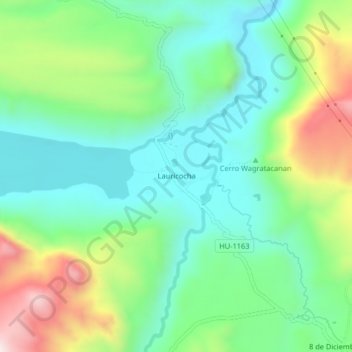
Name: Topografische Karte Lauricocha, Höhe, Relief.
Durchschnittliche Höhe: 4.002 m
Minimale Höhe: 3.819 m
Maximale Höhe: 4.402 m
Lauricocha is located at 10°19′20″S 76°40′00″W / 10.32222°S 76.66667°W / -10.32222; -76.66667 on the shores of Lago Lauricocha in the Huánuco Region. The parish consists of half a dozen houses, scattered at an elevation of 3,850 m in a sparsely populated area near the village of Antacolpa, and 25 km northwest of Yanahuanca, the capital of the province of Daniel Alcides Carrión.