
Topografische Karte Highland County
Interaktive Karte
Klicken Sie auf die Karte, um die Höhe anzuzeigen.
Über diese Karte
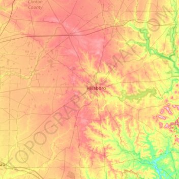
Name: Topografische Karte Highland County, Höhe, Relief.
Ort: Highland County, Ohio, United States of America (39.01846 -83.87217 39.37876 -83.34395)
Durchschnittliche Höhe: 305 m
Minimale Höhe: 203 m
Maximale Höhe: 401 m
Highland County is a county located in the U.S. state of Ohio. As of the 2010 census, the population was 43,589. Its county seat is Hillsboro. The county is named for the topography which is hilly and divides the watersheds of the Little Miami and Scioto Rivers.
Andere topografische Karten
Klicken Sie auf eine Karte, um ihre Topografie, ihre Höhe und ihr Relief anzuzeigen.
Williams County
United States of America > Ohio
Williams County, Ohio, United States of America
Durchschnittliche Höhe: 259 m
Defiance County
United States of America > Ohio
Defiance County, Ohio, United States of America
Durchschnittliche Höhe: 225 m
Beechgrove
United States of America > Ohio > Beechgrove
Beechgrove, Darke County, Ohio, United States of America
Durchschnittliche Höhe: 330 m
Toledo
United States of America > Ohio > Toledo
Toledo, Lucas County, Ohio, United States of America
Durchschnittliche Höhe: 185 m
Medina County
United States of America > Ohio
Medina County, Ohio, United States of America
Durchschnittliche Höhe: 306 m