
Topografische Karte Sutton
Interaktive Karte
Klicken Sie auf die Karte, um die Höhe anzuzeigen.
Sutton
The highest point in Sutton is the summit of Mount Hor in the northern corner of town, with an elevation of 2,656 feet (809.5 m) above sea level. The modest elevation of this town gives it a slightly cooler and wetter climate than nearby towns such as St. Johnsbury. Annual snowfall averages well over 100 inches per year at the weather station in the center of town.
Über diese Karte
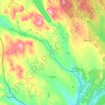
Name: Topografische Karte Sutton, Höhe, Relief.
Ort: Sutton, Caledonia County, Vermont, 05867, United States (44.59017 -72.11436 44.74981 -71.97325)
Durchschnittliche Höhe: 459 m
Minimale Höhe: 224 m
Maximale Höhe: 830 m