
Topografische Karte Durango
Interaktive Karte
Klicken Sie auf die Karte, um die Höhe anzuzeigen.
Durango
Durango (Spanish pronunciation: [duˈɾaŋɡo], Southeastern Tepehuan: Korian), is the capital and largest city of the northern Mexican state of Durango and the seat of the Durango municipality. It has a population of 654,876 as of the 2015 census. The city's official name is Victoria de Durango, Victoria having been added in honor of the first president of Mexico, Guadalupe Victoria, who hailed from the state of Durango. The city is located in the Valley of Guadiana and sits at an altitude of 1,890 m (6,201 ft).
Über diese Karte
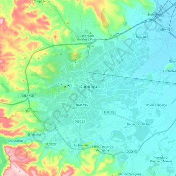
Name: Topografische Karte Durango, Höhe, Relief.
Ort: Durango, Municipio de Durango, Durango, Mexico (23.94563 -104.73078 24.09514 -104.51793)
Durchschnittliche Höhe: 1.936 m
Minimale Höhe: 1.860 m
Maximale Höhe: 2.225 m
Andere topografische Karten
Klicken Sie auf eine Karte, um ihre Topografie, ihre Höhe und ihr Relief anzuzeigen.