
Topografische Karte Δημοτική Ενότητα Διστόμου
Interaktive Karte
Klicken Sie auf die Karte, um die Höhe anzuzeigen.
Über diese Karte
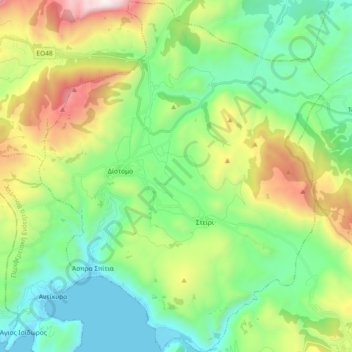
Name: Topografische Karte Δημοτική Ενότητα Διστόμου, Höhe, Relief.
Durchschnittliche Höhe: 571 m
Minimale Höhe: 0 m
Maximale Höhe: 1.890 m
Andere topografische Karten
Klicken Sie auf eine Karte, um ihre Topografie, ihre Höhe und ihr Relief anzuzeigen.
Σκοπιά
Greece > Thessaly and Central Greece > Regional Unit of Boeotia > Municipal Unit of Akrefnia
Σκοπιά, Municipal Unit of Akrefnia, Municipality of Orchomenos, Regional Unit of Boeotia, Central Greece, Thessaly and Central Greece, Greece
Durchschnittliche Höhe: 205 m
Livadia
Greece > Thessaly and Central Greece > Regional Unit of Boeotia > Levadia Municipal Unit
Livadia, Levadia Municipal Unit, Municipality of Livadia, Regional Unit of Boeotia, Central Greece, Thessaly and Central Greece, 321 00, Greece
Durchschnittliche Höhe: 313 m
Tanagra
Greece > Thessaly and Central Greece > Regional Unit of Boeotia > Δημοτική Ενότητα Τανάγρας > Tanagra
Tanagra, Δημοτική Ενότητα Τανάγρας, Municipality of Tanagra, Regional Unit of Boeotia, Central Greece, Thessaly and Central Greece, 32009, Greece
Durchschnittliche Höhe: 231 m