
Topografische Karte Shenley Brook End
Interaktive Karte
Klicken Sie auf die Karte, um die Höhe anzuzeigen.
Über diese Karte
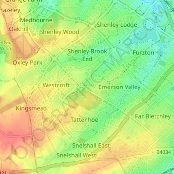
Name: Topografische Karte Shenley Brook End, Höhe, Relief.
Durchschnittliche Höhe: 105 m
Minimale Höhe: 78 m
Maximale Höhe: 131 m
Andere topografische Karten
Klicken Sie auf eine Karte, um ihre Topografie, ihre Höhe und ihr Relief anzuzeigen.
Caldecotte Lake
United Kingdom > England > City of Milton Keynes > Milton Keynes > Fenny Stratford
Caldecotte Lake, Walton, Fenny Stratford, Milton Keynes, City of Milton Keynes, England, United Kingdom
Durchschnittliche Höhe: 75 m
Walton Lake
United Kingdom > England > City of Milton Keynes > Milton Keynes > Monkston
Walton Lake, Woughton on the Green, Old Woughton, Monkston, Milton Keynes, City of Milton Keynes, England, United Kingdom
Durchschnittliche Höhe: 73 m
Shenley Church End
United Kingdom > England > City of Milton Keynes > Milton Keynes
Shenley Church End, Milton Keynes, City of Milton Keynes, England, United Kingdom
Durchschnittliche Höhe: 98 m
Furzton Lake
United Kingdom > England > City of Milton Keynes > Milton Keynes > Bletchley
Furzton Lake, Furzton, Bletchley, Milton Keynes, City of Milton Keynes, England, United Kingdom
Durchschnittliche Höhe: 93 m
Milton Keynes
United Kingdom > England > City of Milton Keynes > Milton Keynes
Milton Keynes, City of Milton Keynes, England, United Kingdom
Durchschnittliche Höhe: 90 m