
Topografische Karte Vysoké Tatry - Starý Smokovec
Interaktive Karte
Klicken Sie auf die Karte, um die Höhe anzuzeigen.
Über diese Karte
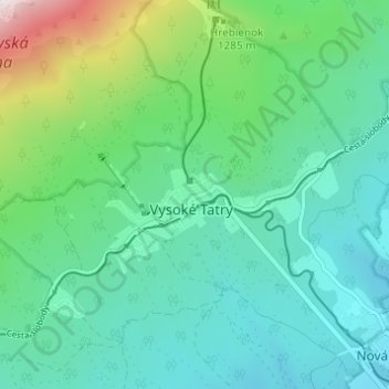
Name: Topografische Karte Vysoké Tatry - Starý Smokovec, Höhe, Relief.
Durchschnittliche Höhe: 1.069 m
Minimale Höhe: 804 m
Maximale Höhe: 2.015 m
Andere topografische Karten
Klicken Sie auf eine Karte, um ihre Topografie, ihre Höhe und ihr Relief anzuzeigen.
Tatranská Lomnica
Slovakia > Region of Prešov > District of Poprad > Vysoké Tatry
Tatranská Lomnica, Vysoké Tatry, District of Poprad, Region of Prešov, Eastern Slovakia, 059 60, Slovakia
Durchschnittliche Höhe: 915 m
Czerwone Wierchy / Červené vrchy
Slovakia > Region of Prešov > District of Poprad > Vysoké Tatry
Czerwone Wierchy / Červené vrchy, Štrbské Pleso, Vysoké Tatry, District of Poprad, Region of Prešov, Eastern Slovakia, Slovakia
Durchschnittliche Höhe: 1.730 m
Vysoké Tatry - Tatranské Matliare
Slovakia > Region of Prešov > District of Poprad > Vysoké Tatry
Vysoké Tatry - Tatranské Matliare, Tatranská Lomnica, Vysoké Tatry, District of Poprad, Region of Prešov, Eastern Slovakia, 059 60, Slovakia
Durchschnittliche Höhe: 900 m
Rysy
Slovakia > Region of Prešov > District of Poprad > Vysoké Tatry
Rysy, Vysoké Tatry, District of Poprad, Region of Prešov, Eastern Slovakia, Slovakia
Durchschnittliche Höhe: 2.005 m