
Topografische Karte Butajiri-Silti Field
Interaktive Karte
Klicken Sie auf die Karte, um die Höhe anzuzeigen.
Über diese Karte
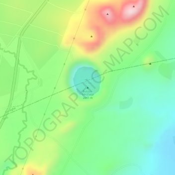
Name: Topografische Karte Butajiri-Silti Field, Höhe, Relief.
Ort: Butajiri-Silti Field, Guraghe, Südliche Nationen, Äthiopien (8.04330 38.35148 8.04340 38.35158)
Durchschnittliche Höhe: 2.092 m
Minimale Höhe: 1.970 m
Maximale Höhe: 2.274 m
Andere topografische Karten
Klicken Sie auf eine Karte, um ihre Topografie, ihre Höhe und ihr Relief anzuzeigen.
Kibish
Äthiopien > Südliche Nationen > Kibish
Kibish, Benji Maji, Südliche Nationen, Äthiopien
Durchschnittliche Höhe: 1.014 m
ቦንጋ / Bonga
Äthiopien > Südliche Nationen > ቦንጋ / Bonga
ቦንጋ / Bonga, Kaffa, Südliche Nationen, Äthiopien
Durchschnittliche Höhe: 1.769 m
Attat
Äthiopien > Südliche Nationen > Attat
Attat, Guraghe, Südliche Nationen, Äthiopien
Durchschnittliche Höhe: 1.908 m
Emdibir
Äthiopien > Südliche Nationen > Emdibir
Emdibir, Guraghe, Südliche Nationen, Äthiopien
Durchschnittliche Höhe: 2.084 m
Korath Range
Korath Range, South Omo, Südliche Nationen, Äthiopien
Durchschnittliche Höhe: 633 m
Tosa Sucha
Äthiopien > Südliche Nationen > አርባ ምንጭ / Arba Minch
Tosa Sucha, አርባ ምንጭ / Arba Minch, Gamo Gofa, Südliche Nationen, Äthiopien
Durchschnittliche Höhe: 1.376 m
Chiracha
Chiracha, Sidama, Südliche Nationen, Äthiopien
Durchschnittliche Höhe: 1.458 m
Jinka
Äthiopien > Südliche Nationen > Jinka
Jinka, South Omo, Südliche Nationen, Äthiopien
Durchschnittliche Höhe: 1.478 m
Chamosee
Äthiopien > Südliche Nationen > አርባ ምንጭ / Arba Minch
Chamosee, Gamo Gofa, Südliche Nationen, 40, Äthiopien
Durchschnittliche Höhe: 1.182 m
Teppi
Teppi, Shaka, Südliche Nationen, Äthiopien
Durchschnittliche Höhe: 2.554 m