
Topografische Karte Municipality of Syros and Ermoupoli
Interaktive Karte
Klicken Sie auf die Karte, um die Höhe anzuzeigen.
Über diese Karte
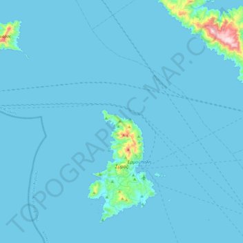
Name: Topografische Karte Municipality of Syros and Ermoupoli, Höhe, Relief.
Durchschnittliche Höhe: 20 m
Minimale Höhe: 0 m
Maximale Höhe: 630 m
Andere topografische Karten
Klicken Sie auf eine Karte, um ihre Topografie, ihre Höhe und ihr Relief anzuzeigen.
Καμάρα
Greece > Aegean > Syros Regional Unit > Ano Syros
Καμάρα, Ano Syros, Municipality of Syros and Ermoupoli, Syros Regional Unit, South Aegean, Aegean, 841 00, Greece
Durchschnittliche Höhe: 119 m
Ermoupoli
Greece > Aegean > Syros Regional Unit
Ermoupoli, Municipality of Syros and Ermoupoli, Syros Regional Unit, South Aegean, Aegean, 841 00, Greece
Durchschnittliche Höhe: 75 m
Syros
Greece > Aegean > Syros Regional Unit > Mesaria
Syros, Mesaria, Municipality of Syros and Ermoupoli, Syros Regional Unit, South Aegean, Aegean, 841 00, Greece
Durchschnittliche Höhe: 32 m
Malia
Greece > Aegean > Syros Regional Unit > Episkopio
Malia, Episkopio, Municipality of Syros and Ermoupoli, Syros Regional Unit, South Aegean, Aegean, 841 00, Greece
Durchschnittliche Höhe: 95 m