
Topografische Karte Morogoro Region
Interaktive Karte
Klicken Sie auf die Karte, um die Höhe anzuzeigen.
Über diese Karte
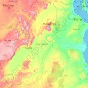
Name: Topografische Karte Morogoro Region, Höhe, Relief.
Ort: Morogoro Region, Coastal Zone, Tanzania (-9.92346 35.32406 -5.80227 38.51660)
Durchschnittliche Höhe: 539 m
Minimale Höhe: 0 m
Maximale Höhe: 2.560 m
The Morogoro region has a total size of 73,039 square kilometers, which is split between land (70,967 square kilometers, or 97.2 percent of the total area), and water (2,073 km2 or 2.8 percent). As of 2012, Ulanga District is the largest district,Malinyi DC comes in second with 17.0 percent of the region's total land area, followed by Morogoro DC with 16.1 percent. Kilosa District comes in first with 18.6 percent. Morogoro Municipal was the district with the smallest land size (531 km2 or 10.7%), followed by Gairo DC with (1,851 km2 or 2.5 percent). Different scenarios exist in Kilosa DC, Malinyi DC, Ifakara TC, Ulanga DC, Morogoro MC, and Gairo DC, with all of their respective territories being completely covered by land. While Mvomero DC (1,882 km2) has the most water area in the area. At Mlimba DC, there is the smallest water area (70 km2). According to topographical and ecological zones, the region's soils differ.
Andere topografische Karten
Klicken Sie auf eine Karte, um ihre Topografie, ihre Höhe und ihr Relief anzuzeigen.
Dodoma
Dodoma, Dodoma City, Dodoma Region, Central Zone, 41110, Tanzania
Durchschnittliche Höhe: 1.144 m
Iringa
Iringa, Iringa Region, Southern Highlands Zone, Tanzania
Durchschnittliche Höhe: 1.215 m
Kinondoni
Kinondoni, Kinondoni Municipal, Dar es Salaam, Coastal Zone, 14110, Tanzania
Durchschnittliche Höhe: 12 m
Kingolwira
Kingolwira, Morogoro, Morogoro Region, Coastal Zone, Tanzania
Durchschnittliche Höhe: 483 m
Ndele
Ndele, Uvinza, Kigoma Region, Western Zone, Tanzania
Durchschnittliche Höhe: 786 m
Kiegea A
Kiegea A, Morogoro, Morogoro Region, Coastal Zone, Tanzania
Durchschnittliche Höhe: 541 m
Bariadi Town
Bariadi Town, Simiyu, Lake Zone, Tanzania
Durchschnittliche Höhe: 1.305 m
Maleuts
Maleuts, Makete, Njombe Region, Southern Highlands Zone, Tanzania
Durchschnittliche Höhe: 2.204 m
Kisagani
Kisagani, Tandahimba, Mtwara Region, Coastal Zone, Tanzania
Durchschnittliche Höhe: 234 m
Moshi
Moshi, Moshi Urban, Kilimanjaro, Northern Zone, 25107, Tanzania
Durchschnittliche Höhe: 1.109 m
Serengeti National Park
Serengeti National Park, Ikoma, Serengeti, Mara Region, Lake Zone, Tanzania
Durchschnittliche Höhe: 1.524 m
Mjini
Tanzania > Zanzibar Urban/West
Mjini, Zanzibar Urban/West, Zanzibar, Tanzania
Durchschnittliche Höhe: 15 m
Uhuru Peak
Uhuru Peak, Rombo, Kilimanjaro, Northern Zone, Tanzania
Durchschnittliche Höhe: 5.494 m
Zanzibar North
Zanzibar North, Zanzibar, Tanzania
Durchschnittliche Höhe: 14 m
Mara River
Mara River, Tarime, Mara, Lake Zone, Tanzania
Durchschnittliche Höhe: 1.552 m
Lushoto
Lushoto, Tanga Region, Northern Zone, Tanzania
Durchschnittliche Höhe: 708 m
Machame
Tanzania > Kilimanjaro > Machame
Machame, Hai, Kilimanjaro, Northern Zone, Tanzania
Durchschnittliche Höhe: 1.417 m
Kijitonyama
Tanzania > Coastal Zone > Dar es Salaam
Kijitonyama, Dar es Salaam, Coastal Zone, Tanzania
Durchschnittliche Höhe: 26 m
Lake Manyara
Lake Manyara, Babati, Manyara, Northern Zone, Tanzania
Durchschnittliche Höhe: 1.174 m
Zanzibar Urban/West
Tanzania > Zanzibar Urban/West
Zanzibar Urban/West, Zanzibar, Tanzania
Durchschnittliche Höhe: 14 m
Pemba
Pemba, Wete District, North Pemba, Zanzibar, Tanzania
Durchschnittliche Höhe: 4 m