
Topografische Karte Muides-sur-Loire
Interaktive Karte
Klicken Sie auf die Karte, um die Höhe anzuzeigen.
Über diese Karte
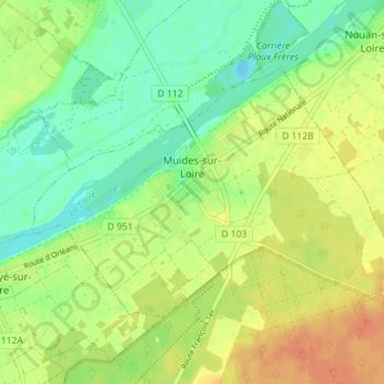
Name: Topografische Karte Muides-sur-Loire, Höhe, Relief.
Durchschnittliche Höhe: 87 m
Minimale Höhe: 68 m
Maximale Höhe: 107 m
Andere topografische Karten
Klicken Sie auf eine Karte, um ihre Topografie, ihre Höhe und ihr Relief anzuzeigen.
Chémery
Frankrijk > Centre-Val de Loire > Loir-et-Cher
Chémery, Romorantin-Lanthenay, Loir-et-Cher, Centre-Val de Loire, Metropolitaans Frankrijk, 41700, Frankrijk
Durchschnittliche Höhe: 106 m
La Batardière
Frankrijk > Centre-Val de Loire > Loir-et-Cher > Montrichard Val de Cher
La Batardière, Bourré, Montrichard Val de Cher, Romorantin-Lanthenay, Loir-et-Cher, Centre-Val de Loire, Metropolitaans Frankrijk, 41400, Frankrijk
Durchschnittliche Höhe: 99 m
Loire
Frankrijk > Centre-Val de Loire > Loir-et-Cher > La Chaussée-Saint-Victor
Loire, La Chaussée-Saint-Victor, Blois, Loir-et-Cher, Centre-Val de Loire, Metropolitaans Frankrijk, 41260, Frankrijk
Durchschnittliche Höhe: 80 m
Le Mauvais Pas
Frankrijk > Centre-Val de Loire > Loir-et-Cher > Cormenon
Le Mauvais Pas, Cormenon, Vendôme, Loir-et-Cher, Centre-Val de Loire, Metropolitaans Frankrijk, 41170, Frankrijk
Durchschnittliche Höhe: 146 m
Mont-près-Chambord
Frankrijk > Centre-Val de Loire > Loir-et-Cher
Mont-près-Chambord, Blois, Loir-et-Cher, Centre-Val de Loire, Metropolitaans Frankrijk, 41250, Frankrijk
Durchschnittliche Höhe: 91 m
Vernou
Frankrijk > Centre-Val de Loire > Loir-et-Cher > Chaumont-sur-Tharonne
Vernou, Chaumont-sur-Tharonne, Romorantin-Lanthenay, Loir-et-Cher, Centre-Val de Loire, Metropolitaans Frankrijk, 41600, Frankrijk
Durchschnittliche Höhe: 127 m
Saint-Bohaire
Frankrijk > Centre-Val de Loire > Loir-et-Cher > Saint-Bohaire
Saint-Bohaire, Blois, Loir-et-Cher, Centre-Val de Loire, Metropolitaans Frankrijk, 41330, Frankrijk
Durchschnittliche Höhe: 109 m