
Topografische Karte Hunter
Interaktive Karte
Klicken Sie auf die Karte, um die Höhe anzuzeigen.
Über diese Karte
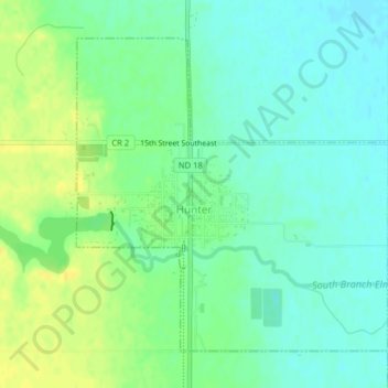
Name: Topografische Karte Hunter, Höhe, Relief.
Ort: Hunter, Cass County, North Dakota, United States (47.18068 -97.22910 47.20246 -97.19711)
Durchschnittliche Höhe: 298 m
Minimale Höhe: 289 m
Maximale Höhe: 311 m
Andere topografische Karten
Klicken Sie auf eine Karte, um ihre Topografie, ihre Höhe und ihr Relief anzuzeigen.
Oxbow
United States > North Dakota > Cass County
Oxbow, Cass County, North Dakota, United States
Durchschnittliche Höhe: 280 m
Harwood
United States > North Dakota > Cass County
Harwood, Cass County, North Dakota, 58042, United States
Durchschnittliche Höhe: 272 m
Fargo
United States > North Dakota > Cass County
Fargo, Cass County, North Dakota, United States
Durchschnittliche Höhe: 277 m
West Fargo
United States > North Dakota > Cass County > West Fargo
West Fargo, Cass County, North Dakota, 58078, United States
Durchschnittliche Höhe: 276 m
Leonard
United States > North Dakota > Cass County > Leonard
Leonard, Cass County, North Dakota, United States
Durchschnittliche Höhe: 320 m
Fargo
United States > North Dakota > Cass County > Fargo
Fargo, Cass County, North Dakota, 58102-4608, United States
Durchschnittliche Höhe: 277 m