
Topografische Karte Avas
Interaktive Karte
Klicken Sie auf die Karte, um die Höhe anzuzeigen.
Über diese Karte
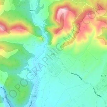
Name: Topografische Karte Avas, Höhe, Relief.
Durchschnittliche Höhe: 163 m
Minimale Höhe: 51 m
Maximale Höhe: 396 m
Andere topografische Karten
Klicken Sie auf eine Karte, um ihre Topografie, ihre Höhe und ihr Relief anzuzeigen.
Samothraki
Greece > Macedonia and Thrace > Evros Regional Unit
Samothraki, Evros Regional Unit, Eastern Macedonia and Thrace, Macedonia and Thrace, 680 02, Greece
Durchschnittliche Höhe: 170 m
Kyprinos
Greece > Macedonia and Thrace > Evros Regional Unit > Kyprinos
Kyprinos, Δήμος Ορεστιάδας, Evros Regional Unit, Eastern Macedonia and Thrace, Macedonia and Thrace, 68006, Greece
Durchschnittliche Höhe: 68 m
Orestiada
Greece > Macedonia and Thrace > Evros Regional Unit > Orestiada
Orestiada, Δήμος Ορεστιάδας, Evros Regional Unit, Eastern Macedonia and Thrace, Macedonia and Thrace, 68200, Greece
Durchschnittliche Höhe: 41 m
Alexandroupoli
Greece > Macedonia and Thrace > Evros Regional Unit
Alexandroupoli, Municipality of Alexandroupoli, Evros Regional Unit, Eastern Macedonia and Thrace, Macedonia and Thrace, 681 00, Greece
Durchschnittliche Höhe: 95 m
Νέα Χηλή
Greece > Macedonia and Thrace > Evros Regional Unit
Νέα Χηλή, Municipality of Alexandroupoli, Evros Regional Unit, Eastern Macedonia and Thrace, Macedonia and Thrace, 681 00, Greece
Durchschnittliche Höhe: 27 m