
Topografische Karte Sierra Madrona
Interaktive Karte
Klicken Sie auf die Karte, um die Höhe anzuzeigen.
Über diese Karte
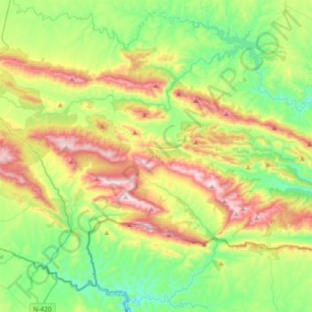
Name: Topografische Karte Sierra Madrona, Höhe, Relief.
Durchschnittliche Höhe: 753 m
Minimale Höhe: 441 m
Maximale Höhe: 1.319 m
Andere topografische Karten
Klicken Sie auf eine Karte, um ihre Topografie, ihre Höhe und ihr Relief anzuzeigen.
Bañuela
España > Castilla-La Mancha > Sierra Morena > Fuencaliente
Bañuela, Fuencaliente, Sierra Morena, Ciudad Real, Castilla-La Mancha, España
Durchschnittliche Höhe: 1.070 m
El Hoyo
España > Castilla-La Mancha > Sierra Morena > Mestanza
El Hoyo, Mestanza, Sierra Morena, Ciudad Real, Castilla-La Mancha, España
Durchschnittliche Höhe: 593 m
Fuencaliente
España > Castilla-La Mancha > Sierra Morena > Fuencaliente
Fuencaliente, Sierra Morena, Ciudad Real, Castilla-La Mancha, España
Durchschnittliche Höhe: 764 m
Ventillas
España > Castilla-La Mancha > Sierra Morena > Fuencaliente > Ventillas
Ventillas, Fuencaliente, Sierra Morena, Ciudad Real, Castilla-La Mancha, España
Durchschnittliche Höhe: 776 m
Mestanza
España > Castilla-La Mancha > Sierra Morena > Mestanza
Mestanza, Sierra Morena, Ciudad Real, Castilla-La Mancha, España
Durchschnittliche Höhe: 725 m