
Topografische Karte Caguba
Interaktive Karte
Klicken Sie auf die Karte, um die Höhe anzuzeigen.
Über diese Karte
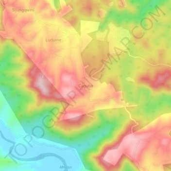
Name: Topografische Karte Caguba, Höhe, Relief.
Durchschnittliche Höhe: 160 m
Minimale Höhe: -5 m
Maximale Höhe: 296 m
Andere topografische Karten
Klicken Sie auf eine Karte, um ihre Topografie, ihre Höhe und ihr Relief anzuzeigen.
Port St Johns
South Africa > Eastern Cape > O.R. Tambo District Municipality > Port St Johns Local Municipality
Port St Johns, Port St Johns Local Municipality, O.R. Tambo District Municipality, Eastern Cape, South Africa
Durchschnittliche Höhe: 85 m