
Spenden
Rüsten Sie sich für Ihr nächstes Abenteuer:
Als Amazon-Partner erhält diese Website eine Provision für qualifizierte Käufe, ohne zusätzliche Kosten für Sie.
Topografische Karte Vaudry
Klicken Sie auf die Karte, um die Höhe anzuzeigen.
Spenden
Rüsten Sie sich für Ihr nächstes Abenteuer:
Als Amazon-Partner erhält diese Website eine Provision für qualifizierte Käufe, ohne zusätzliche Kosten für Sie.
Über diese Karte
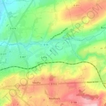
Name: Topografische Karte Vaudry, Höhe, Relief.
Durchschnittliche Höhe: 176 m
Minimale Höhe: 87 m
Maximale Höhe: 292 m
Spenden
Rüsten Sie sich für Ihr nächstes Abenteuer:
Als Amazon-Partner erhält diese Website eine Provision für qualifizierte Käufe, ohne zusätzliche Kosten für Sie.
Andere topografische Karten
Klicken Sie auf eine Karte, um ihre Topografie, ihre Höhe und ihr Relief anzuzeigen.
Spenden
Rüsten Sie sich für Ihr nächstes Abenteuer:
Als Amazon-Partner erhält diese Website eine Provision für qualifizierte Käufe, ohne zusätzliche Kosten für Sie.
Les Hauts Vents
France > Normandie > Calvados > Vire Normandie > Roullours
Durchschnittliche Höhe: 204 m
Vaux de Vire
France > Normandie > Calvados > Vire Normandie > Vire > La Petite Motte
Durchschnittliche Höhe: 165 m
Spenden
Rüsten Sie sich für Ihr nächstes Abenteuer:
Als Amazon-Partner erhält diese Website eine Provision für qualifizierte Käufe, ohne zusätzliche Kosten für Sie.
Sainte-Honorine
France > Normandie > Calvados > Vire Normandie > Sainte-Honorine
Durchschnittliche Höhe: 164 m
La Blanquière
France > Normandie > Calvados > Vire Normandie > La Blanquière
Durchschnittliche Höhe: 136 m
Spenden
Rüsten Sie sich für Ihr nächstes Abenteuer:
Als Amazon-Partner erhält diese Website eine Provision für qualifizierte Käufe, ohne zusätzliche Kosten für Sie.