
Topografische Karte Kingham
Interaktive Karte
Klicken Sie auf die Karte, um die Höhe anzuzeigen.
Über diese Karte
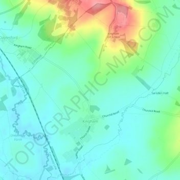
Name: Topografische Karte Kingham, Höhe, Relief.
Durchschnittliche Höhe: 130 m
Minimale Höhe: 104 m
Maximale Höhe: 203 m
Andere topografische Karten
Klicken Sie auf eine Karte, um ihre Topografie, ihre Höhe und ihr Relief anzuzeigen.
Chadlington
United Kingdom > England > Oxfordshire > West Oxfordshire > Charlbury
Chadlington, Charlbury, West Oxfordshire, Oxfordshire, England, United Kingdom
Durchschnittliche Höhe: 161 m
Kelmscott
United Kingdom > England > Oxfordshire > West Oxfordshire
Kelmscott, West Oxfordshire, Oxfordshire, England, United Kingdom
Durchschnittliche Höhe: 73 m
Witney
United Kingdom > England > Oxfordshire > West Oxfordshire
Witney, West Oxfordshire, Oxfordshire, England, United Kingdom
Durchschnittliche Höhe: 92 m
Hailey
United Kingdom > England > Oxfordshire > West Oxfordshire
Hailey, West Oxfordshire, Oxfordshire, England, United Kingdom
Durchschnittliche Höhe: 113 m
Lyneham
United Kingdom > England > Oxfordshire > West Oxfordshire
Lyneham, West Oxfordshire, Oxfordshire, England, United Kingdom
Durchschnittliche Höhe: 130 m
Chipping Norton
United Kingdom > England > Oxfordshire > West Oxfordshire > Chipping Norton
Chipping Norton, West Oxfordshire, Oxfordshire, England, United Kingdom
Durchschnittliche Höhe: 194 m