
Topografische Karte Villamaría
Interaktive Karte
Klicken Sie auf die Karte, um die Höhe anzuzeigen.
Über diese Karte
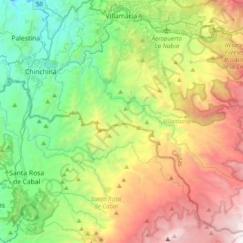
Name: Topografische Karte Villamaría, Höhe, Relief.
Ort: Villamaría, Centrosur, Caldas, Región Andina, Colombia (4.80251 -75.58937 5.05226 -75.31738)
Durchschnittliche Höhe: 2.403 m
Minimale Höhe: 1.060 m
Maximale Höhe: 4.785 m
Las variaciones altitudinales otorgan al municipio de Villamaría la posibilidad de tener tres pisos térmicos, identificados en microrregiones (zona alta o de páramo, zona media u hortofrutícula, zona baja cafetera), con un potencial productivo y turístico.
Andere topografische Karten
Klicken Sie auf eine Karte, um ihre Topografie, ihre Höhe und ihr Relief anzuzeigen.
Villamaría
Colombia > Caldas > Villamaría
Villamaría, Centrosur, Caldas, 176001, Colombia
Durchschnittliche Höhe: 1.947 m