
Topografische Karte Tilicho Lake
Interaktive Karte
Klicken Sie auf die Karte, um die Höhe anzuzeigen.
Über diese Karte
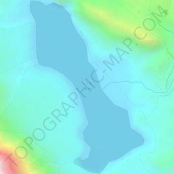
Name: Topografische Karte Tilicho Lake, Höhe, Relief.
Ort: Tilicho Lake, Neshyang-09, Neshyang, मनाङ, Gandaki, Népal (28.67386 83.83970 28.70828 83.86562)
Durchschnittliche Höhe: 5.062 m
Minimale Höhe: 4.903 m
Maximale Höhe: 6.079 m
Le lac Tilicho est un des lacs les plus hauts du monde. Il se situe à 4 919 m d'altitude dans la région des Annapurna dans le massif de l'Himalaya au Népal. Il a été découvert par l'expédition d'alpinisme française de 1950 à l'Annapurna, qui effectuait alors une reconnaissance pour trouver les voies d'accès vers le sommet. Les cartes de la région, encore très sommaires, ont ensuite été redessinées et fait apparaître le lac.
Andere topografische Karten
Klicken Sie auf eine Karte, um ihre Topografie, ihre Höhe und ihr Relief anzuzeigen.