
Spenden
Rüsten Sie sich für Ihr nächstes Abenteuer:
Als Amazon-Partner erhält diese Website eine Provision für qualifizierte Käufe, ohne zusätzliche Kosten für Sie.
Topografische Karte Portland
Klicken Sie auf die Karte, um die Höhe anzuzeigen.
Spenden
Rüsten Sie sich für Ihr nächstes Abenteuer:
Als Amazon-Partner erhält diese Website eine Provision für qualifizierte Käufe, ohne zusätzliche Kosten für Sie.
Über diese Karte
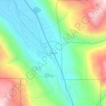
Name: Topografische Karte Portland, Höhe, Relief.
Ort: Portland, Ouray County, Colorado, United States (38.06138 -107.72145 38.10138 -107.68145)
Durchschnittliche Höhe: 2.478 m
Minimale Höhe: 2.175 m
Maximale Höhe: 3.041 m
Spenden
Rüsten Sie sich für Ihr nächstes Abenteuer:
Als Amazon-Partner erhält diese Website eine Provision für qualifizierte Käufe, ohne zusätzliche Kosten für Sie.
Andere topografische Karten
Klicken Sie auf eine Karte, um ihre Topografie, ihre Höhe und ihr Relief anzuzeigen.
Ridgway
United States > Colorado > Ouray County
Ridgway is situated in the Uncompahgre Valley at an elevation of 6,985 feet (2,129 m). The town is located on the San Juan Skyway, cradled in the heart of some of the most photographed mountains in the world. The nearby San Juan Mountain Range has 14 of Colorado's 53 peaks over 14,000 feet. Among them, 14,150…
Durchschnittliche Höhe: 2.173 m
Ouray
United States > Colorado > Ouray County
Ouray (/ˈjʊəreɪ/ YOOR-ay) is a home rule municipality that is the county seat of Ouray County, Colorado, United States. The city population was 898 as of the 2020 census. The Ouray Post Office has the ZIP Code 81427. Located at an elevation of 7,792 feet (2,375 m), Ouray's climate, natural alpine…
Durchschnittliche Höhe: 2.717 m
Ridgway
United States > Colorado > Ouray County
Ridgway is situated in the Uncompahgre Valley at an elevation of 6,985 feet (2,129 m). The town is located on the San Juan Skyway, cradled in the heart of some of the most photographed mountains in the world. The nearby San Juan Mountain Range has 14 of Colorado's 53 peaks over 14,000 feet. Among them, 14,150…
Durchschnittliche Höhe: 2.173 m
Spenden
Rüsten Sie sich für Ihr nächstes Abenteuer:
Als Amazon-Partner erhält diese Website eine Provision für qualifizierte Käufe, ohne zusätzliche Kosten für Sie.